You are here: Home > Network List > IU - Global Seismograph Network (GSN - IRIS/USGS) Stations List
> Station MAJO Matsushiro, Japan > Earthquake Result Viewer
MAJO Matsushiro, Japan - Earthquake Result Viewer
| Earthquake location: |
Fiji Islands |
| Earthquake latitude/longitude: |
-17.2/178.3 |
| Earthquake time(UTC): |
2009/11/09 (313) 10:44:54 GMT |
| Earthquake Depth: |
591 km |
| Earthquake Magnitude: |
6.6 MB, 7.3 MW, 7.2 MW |
| Earthquake Catalog/Contributor: |
WHDF/NEIC |
|
| Network: |
IU Global Seismograph Network (GSN - IRIS/USGS) |
| Station: |
MAJO Matsushiro, Japan |
| Lat/Lon: |
36.55 N/138.20 E |
| Elevation: |
405 m |
|
| Distance: |
65.6 deg |
| Az: |
325.24 deg |
| Baz: |
137.422 deg |
| Ray Param: |
0.056009933 |
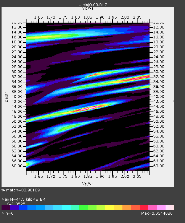
| Estimated Moho Depth: |
44.5 km |
| Estimated Crust Vp/Vs: |
1.85 |
| Assumed Crust Vp: |
6.461 km/s |
| Estimated Crust Vs: |
3.488 km/s |
| Estimated Crust Poisson's Ratio: |
0.29 |
|
| Radial Match: |
88.98109 % |
| Radial Bump: |
400 |
| Transverse Match: |
89.018555 % |
| Transverse Bump: |
400 |
| SOD ConfigId: |
626211 |
| Insert Time: |
2013-10-07 14:23:04.697 +0000 |
| GWidth: |
2.5 |
| Max Bumps: |
400 |
| Tol: |
0.001 |
|

Signal To Noise
| Channel | StoN | STA | LTA |
| IU:MAJO:00:BHZ:20091109T10:54:10.168987Z | 72.30291 | 1.2863742E-5 | 1.7791457E-7 |
| IU:MAJO:00:BH1:20091109T10:54:10.168987Z | 0.5038608 | 5.1340803E-9 | 1.0189481E-8 |
| IU:MAJO:00:BH2:20091109T10:54:10.168987Z | 31.938972 | 3.7550808E-6 | 1.17570494E-7 |
| Arrivals |
| Ps | 6.1 SECOND |
| PpPs | 19 SECOND |
| PsPs/PpSs | 25 SECOND |


