You are here: Home > Network List > CI - Caltech Regional Seismic Network Stations List
> Station TIN Tinemaha, California, USA > Earthquake Result Viewer
TIN Tinemaha, California, USA - Earthquake Result Viewer

| Earthquake location: |
Near Coast Of Central Chile |
| Earthquake latitude/longitude: |
-30.9/-71.2 |
| Earthquake time(UTC): |
1997/10/15 (288) 01:03:33 GMT |
| Earthquake Depth: |
58 km |
| Earthquake Magnitude: |
6.8 MB, 6.8 MS, 7.3 UNKNOWN, 7.1 MW |
| Earthquake Catalog/Contributor: |
WHDF/NEIC |
|
| Network: |
CI Caltech Regional Seismic Network |
| Station: |
TIN Tinemaha, California, USA |
| Lat/Lon: |
37.05 N/118.23 W |
| Elevation: |
1164 m |
|
| Distance: |
80.7 deg |
| Az: |
323.63 deg |
| Baz: |
140.436 deg |
| Ray Param: |
0.048000857 |
| Estimated Moho Depth: |
62.5 km |
| Estimated Crust Vp/Vs: |
1.79 |
| Assumed Crust Vp: |
6.291 km/s |
| Estimated Crust Vs: |
3.52 km/s |
| Estimated Crust Poisson's Ratio: |
0.27 |
|
| Radial Match: |
94.6155 % |
| Radial Bump: |
400 |
| Transverse Match: |
83.80236 % |
| Transverse Bump: |
400 |
| SOD ConfigId: |
4770 |
| Insert Time: |
2010-02-25 20:49:05.329 +0000 |
| GWidth: |
2.5 |
| Max Bumps: |
400 |
| Tol: |
0.001 |
|
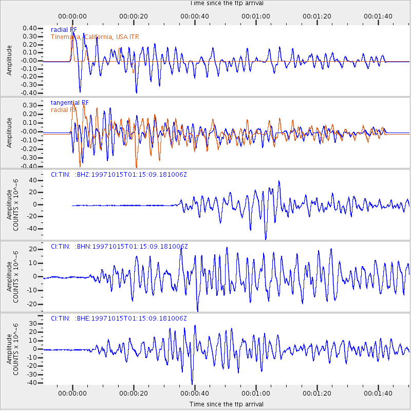
Signal To Noise
| Channel | StoN | STA | LTA |
| CI:TIN: :BHN:19971015T01:15:09.181006Z | 0.80637884 | 2.1707493E-7 | 2.6919722E-7 |
| CI:TIN: :BHE:19971015T01:15:09.181006Z | 1.4050839 | 2.2328777E-7 | 1.5891419E-7 |
| CI:TIN: :BHZ:19971015T01:15:09.181006Z | 5.767714 | 6.6980454E-7 | 1.1612998E-7 |
| Arrivals |
| Ps | 8.0 SECOND |
| PpPs | 27 SECOND |
| PsPs/PpSs | 35 SECOND |


