You are here: Home > Network List > IU - Global Seismograph Network (GSN - IRIS/USGS) Stations List
> Station COR Corvallis, Oregon, USA > Earthquake Result Viewer
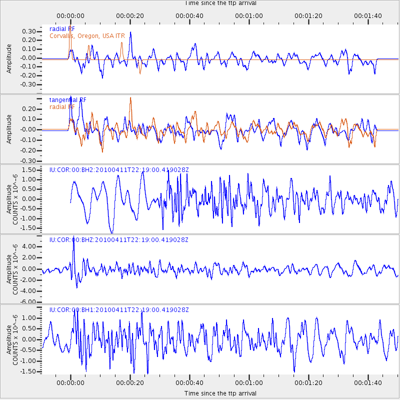
COR Corvallis, Oregon, USA - Earthquake Result Viewer
*The percent match for this event was below the threshold and hence no stack was calculated.
| Earthquake location: |
Strait Of Gibraltar |
| Earthquake latitude/longitude: |
37.0/-3.5 |
| Earthquake time(UTC): |
2010/04/11 (101) 22:08:12 GMT |
| Earthquake Depth: |
610 km |
| Earthquake Magnitude: |
6.3 MW, 6.0 MB, 6.3 MW |
| Earthquake Catalog/Contributor: |
NEIC PDE/NEIC PDE-M |
|
| Network: |
IU Global Seismograph Network (GSN - IRIS/USGS) |
| Station: |
COR Corvallis, Oregon, USA |
| Lat/Lon: |
44.59 N/123.30 W |
| Elevation: |
110 m |
|
| Distance: |
82.3 deg |
| Az: |
321.244 deg |
| Baz: |
44.563 deg |
| Ray Param: |
$rayparam |
*The percent match for this event was below the threshold and hence was not used in the summary stack. |
|
| Radial Match: |
46.800526 % |
| Radial Bump: |
400 |
| Transverse Match: |
50.923035 % |
| Transverse Bump: |
400 |
| SOD ConfigId: |
626211 |
| Insert Time: |
2013-10-07 22:34:16.050 +0000 |
| GWidth: |
2.5 |
| Max Bumps: |
400 |
| Tol: |
0.001 |
|
Signal To Noise
| Channel | StoN | STA | LTA |
| IU:COR:00:BHZ:20100411T22:19:00.419028Z | 4.314703 | 2.0505884E-6 | 4.7525594E-7 |
| IU:COR:00:BH1:20100411T22:19:00.419028Z | 1.8946655 | 7.003944E-7 | 3.6966654E-7 |
| IU:COR:00:BH2:20100411T22:19:00.419028Z | 0.8545851 | 6.538706E-7 | 7.6513226E-7 |
| Arrivals |
| Ps | |
| PpPs | |
| PsPs/PpSs | |


