You are here: Home > Network List > IU - Global Seismograph Network (GSN - IRIS/USGS) Stations List
> Station COR Corvallis, Oregon, USA > Earthquake Result Viewer
COR Corvallis, Oregon, USA - Earthquake Result Viewer
| Earthquake location: |
Near Coast Of Northern Chile |
| Earthquake latitude/longitude: |
-18.1/-70.5 |
| Earthquake time(UTC): |
2010/05/06 (126) 02:42:47 GMT |
| Earthquake Depth: |
37 km |
| Earthquake Magnitude: |
6.2 MW, 5.9 MS, 6.2 MW, 6.7 MB |
| Earthquake Catalog/Contributor: |
NEIC PDE/NEIC PDE-M |
|
| Network: |
IU Global Seismograph Network (GSN - IRIS/USGS) |
| Station: |
COR Corvallis, Oregon, USA |
| Lat/Lon: |
44.59 N/123.30 W |
| Elevation: |
110 m |
|
| Distance: |
78.7 deg |
| Az: |
324.544 deg |
| Baz: |
129.438 deg |
| Ray Param: |
0.049405493 |
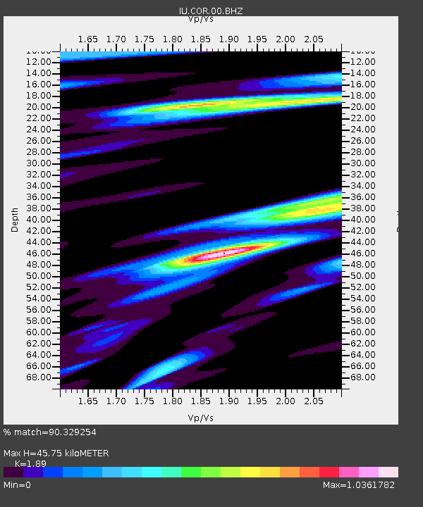
| Estimated Moho Depth: |
45.75 km |
| Estimated Crust Vp/Vs: |
1.89 |
| Assumed Crust Vp: |
6.566 km/s |
| Estimated Crust Vs: |
3.474 km/s |
| Estimated Crust Poisson's Ratio: |
0.31 |
|
| Radial Match: |
90.329254 % |
| Radial Bump: |
400 |
| Transverse Match: |
78.89481 % |
| Transverse Bump: |
400 |
| SOD ConfigId: |
626211 |
| Insert Time: |
2013-10-07 23:35:17.663 +0000 |
| GWidth: |
2.5 |
| Max Bumps: |
400 |
| Tol: |
0.001 |
|
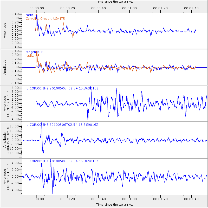
Signal To Noise
| Channel | StoN | STA | LTA |
| IU:COR:00:BHZ:20100506T02:54:15.369016Z | 33.094048 | 7.6071024E-6 | 2.2986316E-7 |
| IU:COR:00:BH1:20100506T02:54:15.369016Z | 4.722566 | 1.6298625E-6 | 3.4512223E-7 |
| IU:COR:00:BH2:20100506T02:54:15.369016Z | 4.486205 | 1.6398398E-6 | 3.655294E-7 |
| Arrivals |
| Ps | 6.4 SECOND |
| PpPs | 20 SECOND |
| PsPs/PpSs | 26 SECOND |


