You are here: Home > Network List > IU - Global Seismograph Network (GSN - IRIS/USGS) Stations List
> Station COR Corvallis, Oregon, USA > Earthquake Result Viewer
COR Corvallis, Oregon, USA - Earthquake Result Viewer
| Earthquake location: |
Vanuatu Islands |
| Earthquake latitude/longitude: |
-13.7/166.6 |
| Earthquake time(UTC): |
2010/05/27 (147) 17:14:46 GMT |
| Earthquake Depth: |
31 km |
| Earthquake Magnitude: |
6.2 MB, 7.1 MS, 7.1 MW, 7.0 MW |
| Earthquake Catalog/Contributor: |
WHDF/NEIC |
|
| Network: |
IU Global Seismograph Network (GSN - IRIS/USGS) |
| Station: |
COR Corvallis, Oregon, USA |
| Lat/Lon: |
44.59 N/123.30 W |
| Elevation: |
110 m |
|
| Distance: |
85.9 deg |
| Az: |
42.334 deg |
| Baz: |
246.349 deg |
| Ray Param: |
0.044428717 |
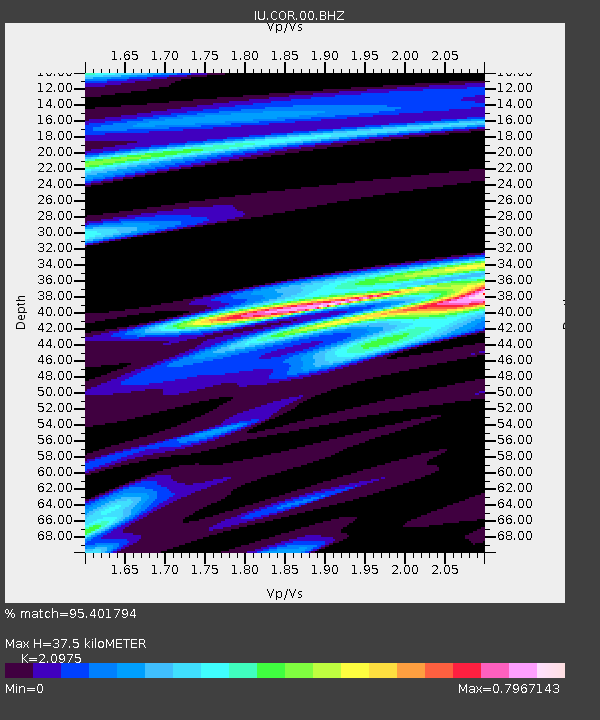
| Estimated Moho Depth: |
37.5 km |
| Estimated Crust Vp/Vs: |
2.10 |
| Assumed Crust Vp: |
6.566 km/s |
| Estimated Crust Vs: |
3.13 km/s |
| Estimated Crust Poisson's Ratio: |
0.35 |
|
| Radial Match: |
95.401794 % |
| Radial Bump: |
307 |
| Transverse Match: |
81.71412 % |
| Transverse Bump: |
400 |
| SOD ConfigId: |
626211 |
| Insert Time: |
2013-10-08 00:17:37.471 +0000 |
| GWidth: |
2.5 |
| Max Bumps: |
400 |
| Tol: |
0.001 |
|
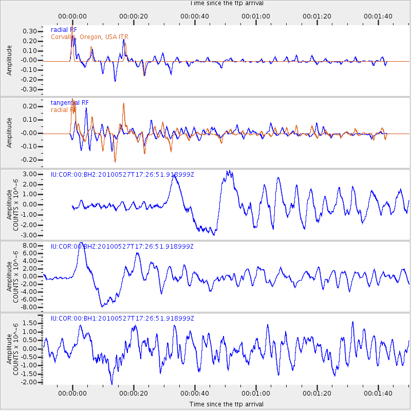
Signal To Noise
| Channel | StoN | STA | LTA |
| IU:COR:00:BHZ:20100527T17:26:51.918999Z | 15.7766 | 5.6041235E-6 | 3.5521745E-7 |
| IU:COR:00:BH1:20100527T17:26:51.918999Z | 2.9889193 | 8.1806394E-7 | 2.7369893E-7 |
| IU:COR:00:BH2:20100527T17:26:51.918999Z | 8.103618 | 1.809168E-6 | 2.2325435E-7 |
| Arrivals |
| Ps | 6.4 SECOND |
| PpPs | 17 SECOND |
| PsPs/PpSs | 24 SECOND |


