You are here: Home > Network List > IU - Global Seismograph Network (GSN - IRIS/USGS) Stations List
> Station COR Corvallis, Oregon, USA > Earthquake Result Viewer
COR Corvallis, Oregon, USA - Earthquake Result Viewer
| Earthquake location: |
Solomon Islands |
| Earthquake latitude/longitude: |
-10.6/161.4 |
| Earthquake time(UTC): |
2010/06/26 (177) 05:30:19 GMT |
| Earthquake Depth: |
35 km |
| Earthquake Magnitude: |
6.4 MB, 6.8 MS, 6.7 MW, 6.6 MW |
| Earthquake Catalog/Contributor: |
WHDF/NEIC |
|
| Network: |
IU Global Seismograph Network (GSN - IRIS/USGS) |
| Station: |
COR Corvallis, Oregon, USA |
| Lat/Lon: |
44.59 N/123.30 W |
| Elevation: |
110 m |
|
| Distance: |
87.1 deg |
| Az: |
43.78 deg |
| Baz: |
252.156 deg |
| Ray Param: |
0.043525342 |
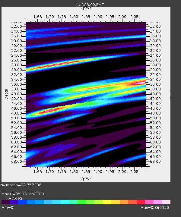
| Estimated Moho Depth: |
35.0 km |
| Estimated Crust Vp/Vs: |
2.10 |
| Assumed Crust Vp: |
6.566 km/s |
| Estimated Crust Vs: |
3.134 km/s |
| Estimated Crust Poisson's Ratio: |
0.35 |
|
| Radial Match: |
87.752396 % |
| Radial Bump: |
400 |
| Transverse Match: |
89.46192 % |
| Transverse Bump: |
400 |
| SOD ConfigId: |
626211 |
| Insert Time: |
2013-10-08 01:18:21.146 +0000 |
| GWidth: |
2.5 |
| Max Bumps: |
400 |
| Tol: |
0.001 |
|
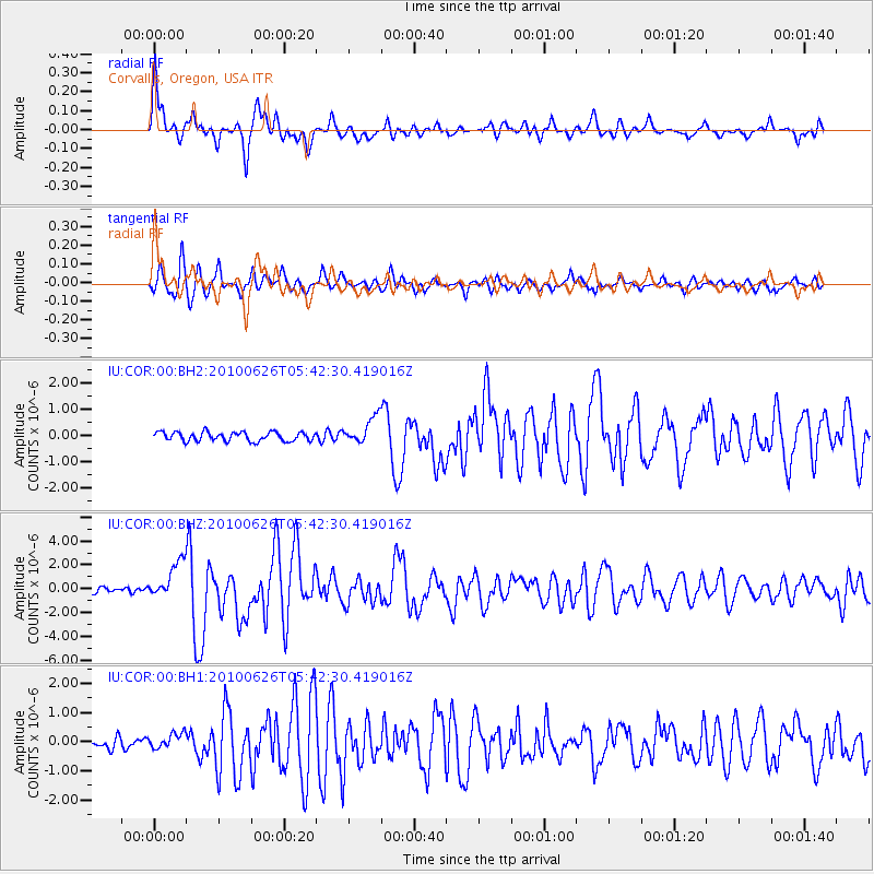
Signal To Noise
| Channel | StoN | STA | LTA |
| IU:COR:00:BHZ:20100626T05:42:30.419016Z | 7.102767 | 1.5529308E-6 | 2.1863744E-7 |
| IU:COR:00:BH1:20100626T05:42:30.419016Z | 1.4760909 | 2.6011907E-7 | 1.7622158E-7 |
| IU:COR:00:BH2:20100626T05:42:30.419016Z | 3.0046961 | 5.1294364E-7 | 1.7071397E-7 |
| Arrivals |
| Ps | 6.0 SECOND |
| PpPs | 16 SECOND |
| PsPs/PpSs | 22 SECOND |


