You are here: Home > Network List > KN - Kyrgyz Seismic Telemetry Network Stations List
> Station TKM2 - > Earthquake Result Viewer
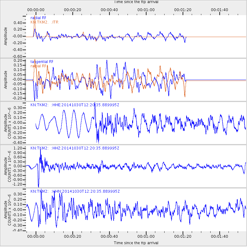
TKM2 - - Earthquake Result Viewer
*The percent match for this event was below the threshold and hence no stack was calculated.
| Earthquake location: |
Bali Sea |
| Earthquake latitude/longitude: |
-7.0/117.6 |
| Earthquake time(UTC): |
2014/10/30 (303) 12:11:36 GMT |
| Earthquake Depth: |
546 km |
| Earthquake Magnitude: |
5.7 MB |
| Earthquake Catalog/Contributor: |
NEIC PDE/NEIC COMCAT |
|
| Network: |
KN Kyrgyz Seismic Telemetry Network |
| Station: |
TKM2 - |
| Lat/Lon: |
42.92 N/75.60 E |
| Elevation: |
2020 m |
|
| Distance: |
62.6 deg |
| Az: |
326.386 deg |
| Baz: |
131.571 deg |
| Ray Param: |
$rayparam |
*The percent match for this event was below the threshold and hence was not used in the summary stack. |
|
| Radial Match: |
50.854946 % |
| Radial Bump: |
400 |
| Transverse Match: |
60.463516 % |
| Transverse Bump: |
400 |
| SOD ConfigId: |
3390531 |
| Insert Time: |
2019-04-14 19:07:31.349 +0000 |
| GWidth: |
2.5 |
| Max Bumps: |
400 |
| Tol: |
0.001 |
|
Signal To Noise
| Channel | StoN | STA | LTA |
| KN:TKM2: :HHZ:20141030T12:20:35.889995Z | 7.5096292 | 5.131371E-7 | 6.833055E-8 |
| KN:TKM2: :HHN:20141030T12:20:35.889995Z | 1.9511391 | 1.6096871E-7 | 8.249987E-8 |
| KN:TKM2: :HHE:20141030T12:20:35.889995Z | 1.2268989 | 1.8636653E-7 | 1.519005E-7 |
| Arrivals |
| Ps | |
| PpPs | |
| PsPs/PpSs | |


