COR Corvallis, Oregon, USA - Earthquake Result Viewer
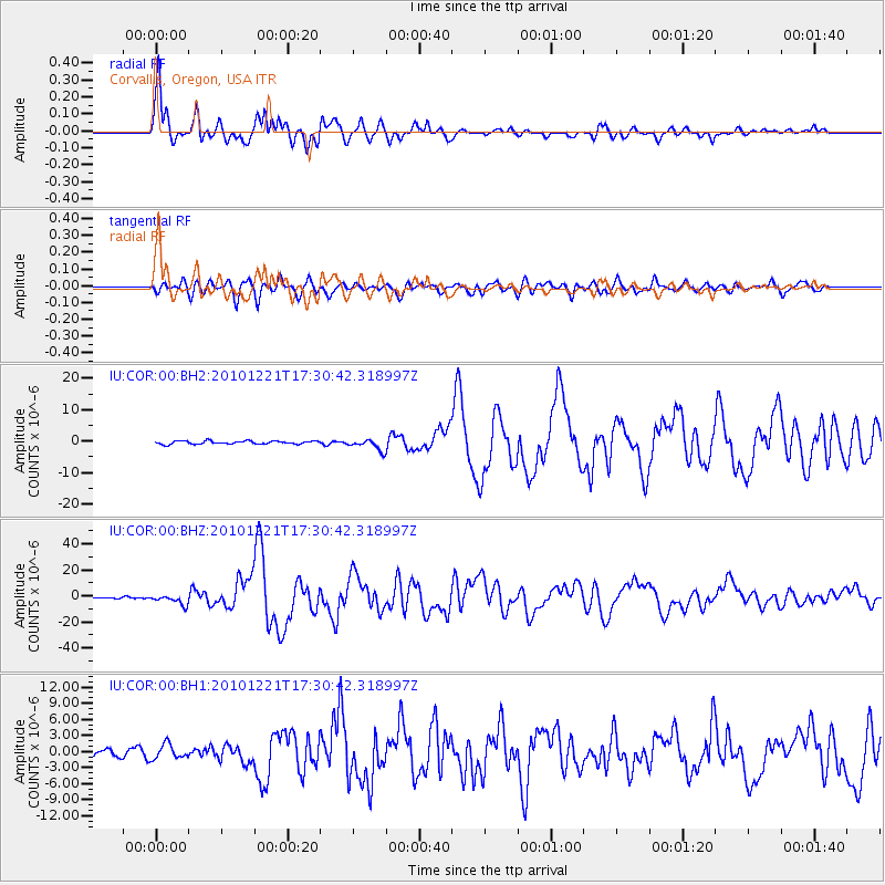
Earthquake location: Bonin Islands, Japan Region
Earthquake latitude/longitude: 26.9/143.7
Earthquake time(UTC): 2010/12/21 (355) 17:19:40 GMT
Earthquake Depth: 14 km
Earthquake Magnitude: 7.4 MW, 7.0 MB, 7.4 MW, 7.5 MS
Earthquake Catalog/Contributor: NEIC PDE/NEIC PDE-M
Network: IU Global Seismograph Network (GSN - IRIS/USGS)
Station: COR Corvallis, Oregon, USA
Lat/Lon: 44.59 N/123.30 W
Elevation: 110 m
Distance: 73.7 deg
Az: 48.043 deg
Baz: 291.664 deg
Ray Param: 0.05285371
Estimated Moho Depth: 36.5 km
Estimated Crust Vp/Vs: 2.10
Assumed Crust Vp: 6.566 km/s
Estimated Crust Vs: 3.13 km/s
Estimated Crust Poisson's Ratio: 0.35
Radial Match: 97.3879 %
Radial Bump: 351
Transverse Match: 88.40147 %
Transverse Bump: 400
SOD ConfigId: 626211
Insert Time: 2013-10-08 09:09:19.415 +0000
GWidth: 2.5
Max Bumps: 400
Tol: 0.001

Signal To Noise

ChannelStoNSTALTA
IU:COR:00:BHZ:20101221T17:30:42.318997Z3.72680543.819049E-61.0247513E-6
IU:COR:00:BH1:20101221T17:30:42.318997Z1.81115841.3557046E-67.4852903E-7
IU:COR:00:BH2:20101221T17:30:42.318997Z3.57358931.7558824E-64.913498E-7
Arrivals
Ps6.3 SECOND
PpPs17 SECOND
PsPs/PpSs23 SECOND