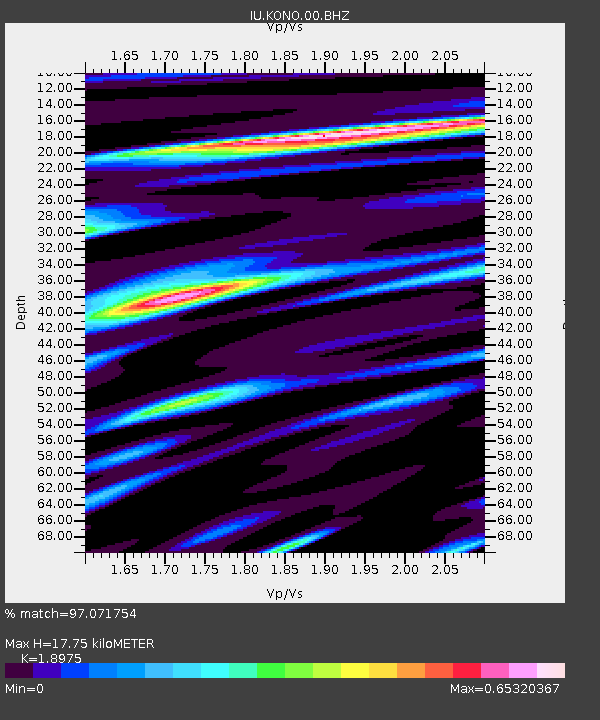
KONO Kongsberg, Norway - Earthquake Result Viewer

Earthquake location: Bonin Islands, Japan Region
Earthquake latitude/longitude: 26.9/143.7
Earthquake time(UTC): 2010/12/21 (355) 17:19:40 GMT
Earthquake Depth: 14 km
Earthquake Magnitude: 7.4 MW, 7.0 MB, 7.4 MW, 7.5 MS
Earthquake Catalog/Contributor: NEIC PDE/NEIC PDE-M
Network: IU Global Seismograph Network (GSN - IRIS/USGS)
Station: KONO Kongsberg, Norway
Lat/Lon: 59.65 N/9.60 E
Elevation: 216 m
Distance: 85.9 deg
Az: 338.553 deg
Baz: 40.014 deg
Ray Param: 0.0444514
Estimated Moho Depth: 17.75 km
Estimated Crust Vp/Vs: 1.90
Assumed Crust Vp: 6.545 km/s
Estimated Crust Vs: 3.449 km/s
Estimated Crust Poisson's Ratio: 0.31
Radial Match: 97.071754 %
Radial Bump: 400
Transverse Match: 91.903656 %
Transverse Bump: 400
SOD ConfigId: 626211
Insert Time: 2013-10-08 09:09:23.446 +0000
GWidth: 2.5
Max Bumps: 400
Tol: 0.001

Signal To Noise

ChannelStoNSTALTA
IU:KONO:00:BHZ:20101221T17:31:48.318997Z16.9800595.7486955E-63.385557E-7
IU:KONO:00:BH1:20101221T17:31:48.318997Z9.1961811.4192011E-61.5432505E-7
IU:KONO:00:BH2:20101221T17:31:48.318997Z5.70130061.0961936E-61.922708E-7
Arrivals
Ps2.5 SECOND
PpPs7.7 SECOND
PsPs/PpSs10 SECOND