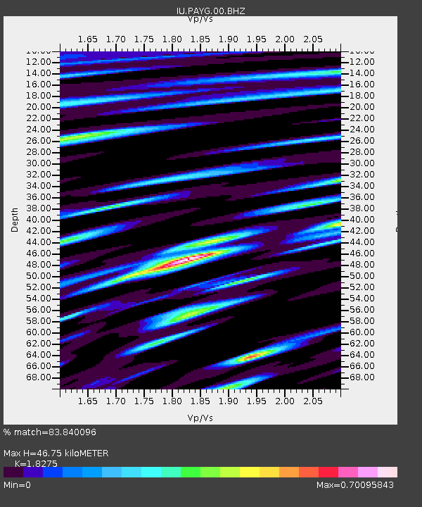
PAYG Puerto Ayora, Galapagos Islands - Earthquake Result Viewer
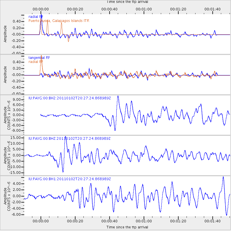
Earthquake location: Near Coast Of Central Chile
Earthquake latitude/longitude: -38.4/-73.3
Earthquake time(UTC): 2011/01/02 (002) 20:20:17 GMT
Earthquake Depth: 24 km
Earthquake Magnitude: 6.6 MB, 7.1 MS, 7.1 MW, 7.0 MW
Earthquake Catalog/Contributor: WHDF/NEIC
Network: IU Global Seismograph Network (GSN - IRIS/USGS)
Station: PAYG Puerto Ayora, Galapagos Islands
Lat/Lon: 0.67 S/90.29 W
Elevation: 270 m
Distance: 40.6 deg
Az: 333.375 deg
Baz: 159.369 deg
Ray Param: 0.074264914
Estimated Moho Depth: 46.75 km
Estimated Crust Vp/Vs: 1.83
Assumed Crust Vp: 4.802 km/s
Estimated Crust Vs: 2.628 km/s
Estimated Crust Poisson's Ratio: 0.29
Radial Match: 83.840096 %
Radial Bump: 400
Transverse Match: 77.466415 %
Transverse Bump: 400
SOD ConfigId: 626211
Insert Time: 2013-10-08 09:47:46.722 +0000
GWidth: 2.5
Max Bumps: 400
Tol: 0.001

Signal To Noise

ChannelStoNSTALTA
IU:PAYG:00:BHZ:20110102T20:27:24.868989Z2.80888.836824E-73.1461207E-7
IU:PAYG:00:BH1:20110102T20:27:24.868989Z0.63286313.228556E-75.1015076E-7
IU:PAYG:00:BH2:20110102T20:27:24.868989Z2.32192288.569817E-73.6908278E-7
Arrivals
Ps8.4 SECOND
PpPs27 SECOND
PsPs/PpSs35 SECOND