You are here: Home > Network List > YE11 - Testing TA and FA Vaults and Directly Buried Sensors (3T) Stations List
> Station PIC2 Poker Flats, Alaska, USA > Earthquake Result Viewer
PIC2 Poker Flats, Alaska, USA - Earthquake Result Viewer
| Earthquake location: |
Near East Coast Of Honshu, Japan |
| Earthquake latitude/longitude: |
38.2/141.9 |
| Earthquake time(UTC): |
2013/08/04 (216) 03:28:50 GMT |
| Earthquake Depth: |
56 km |
| Earthquake Magnitude: |
5.8 MW, 5.8 MB, 5.9 MW |
| Earthquake Catalog/Contributor: |
NEIC PDE/NEIC PDE-W |
|
| Network: |
YE Testing TA and FA Vaults and Directly Buried Sensors (3T) |
| Station: |
PIC2 Poker Flats, Alaska, USA |
| Lat/Lon: |
65.12 N/147.43 W |
| Elevation: |
502 m |
|
| Distance: |
48.1 deg |
| Az: |
32.466 deg |
| Baz: |
271.909 deg |
| Ray Param: |
0.06944802 |
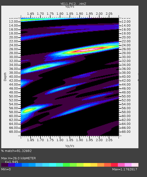
| Estimated Moho Depth: |
26.0 km |
| Estimated Crust Vp/Vs: |
1.95 |
| Assumed Crust Vp: |
6.566 km/s |
| Estimated Crust Vs: |
3.376 km/s |
| Estimated Crust Poisson's Ratio: |
0.32 |
|
| Radial Match: |
91.32692 % |
| Radial Bump: |
352 |
| Transverse Match: |
57.20426 % |
| Transverse Bump: |
400 |
| SOD ConfigId: |
626651 |
| Insert Time: |
2014-04-17 17:57:49.468 +0000 |
| GWidth: |
2.5 |
| Max Bumps: |
400 |
| Tol: |
0.001 |
|

Signal To Noise
| Channel | StoN | STA | LTA |
| YE:PIC2: :HHZ:20130804T03:36:54.140006Z | 11.334304 | 1.1386888E-6 | 1.0046394E-7 |
| YE:PIC2: :HHN:20130804T03:36:54.140006Z | 2.205558 | 2.2573248E-7 | 1.023471E-7 |
| YE:PIC2: :HHE:20130804T03:36:54.140006Z | 7.7113557 | 5.2283315E-7 | 6.780042E-8 |
| Arrivals |
| Ps | 4.0 SECOND |
| PpPs | 11 SECOND |
| PsPs/PpSs | 15 SECOND |


