You are here: Home > Network List > IW - Intermountain West Stations List
> Station MOOW Moose Ponds, Wyoming, USA > Earthquake Result Viewer
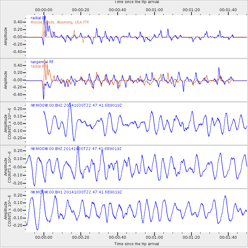
MOOW Moose Ponds, Wyoming, USA - Earthquake Result Viewer
*The percent match for this event was below the threshold and hence no stack was calculated.
| Earthquake location: |
Near Coast Of Peru |
| Earthquake latitude/longitude: |
-16.2/-73.6 |
| Earthquake time(UTC): |
2014/10/30 (303) 22:37:15 GMT |
| Earthquake Depth: |
61 km |
| Earthquake Magnitude: |
5.1 MW |
| Earthquake Catalog/Contributor: |
ISC/ISC |
|
| Network: |
IW Intermountain West |
| Station: |
MOOW Moose Ponds, Wyoming, USA |
| Lat/Lon: |
43.75 N/110.74 W |
| Elevation: |
2128 m |
|
| Distance: |
68.6 deg |
| Az: |
331.953 deg |
| Baz: |
141.426 deg |
| Ray Param: |
$rayparam |
*The percent match for this event was below the threshold and hence was not used in the summary stack. |
|
| Radial Match: |
65.82436 % |
| Radial Bump: |
400 |
| Transverse Match: |
56.45948 % |
| Transverse Bump: |
400 |
| SOD ConfigId: |
3390531 |
| Insert Time: |
2019-04-14 19:14:11.959 +0000 |
| GWidth: |
2.5 |
| Max Bumps: |
400 |
| Tol: |
0.001 |
|
Signal To Noise
| Channel | StoN | STA | LTA |
| IW:MOOW:00:BHZ:20141030T22:47:41.689019Z | 0.987025 | 8.819836E-8 | 8.9357776E-8 |
| IW:MOOW:00:BH1:20141030T22:47:41.689019Z | 1.9173669 | 1.4037664E-7 | 7.321324E-8 |
| IW:MOOW:00:BH2:20141030T22:47:41.689019Z | 0.76979214 | 8.151815E-8 | 1.0589631E-7 |
| Arrivals |
| Ps | |
| PpPs | |
| PsPs/PpSs | |


