You are here: Home > Network List > TA - USArray Transportable Network (new EarthScope stations) Stations List
> Station MDND Maddock, ND, USA > Earthquake Result Viewer
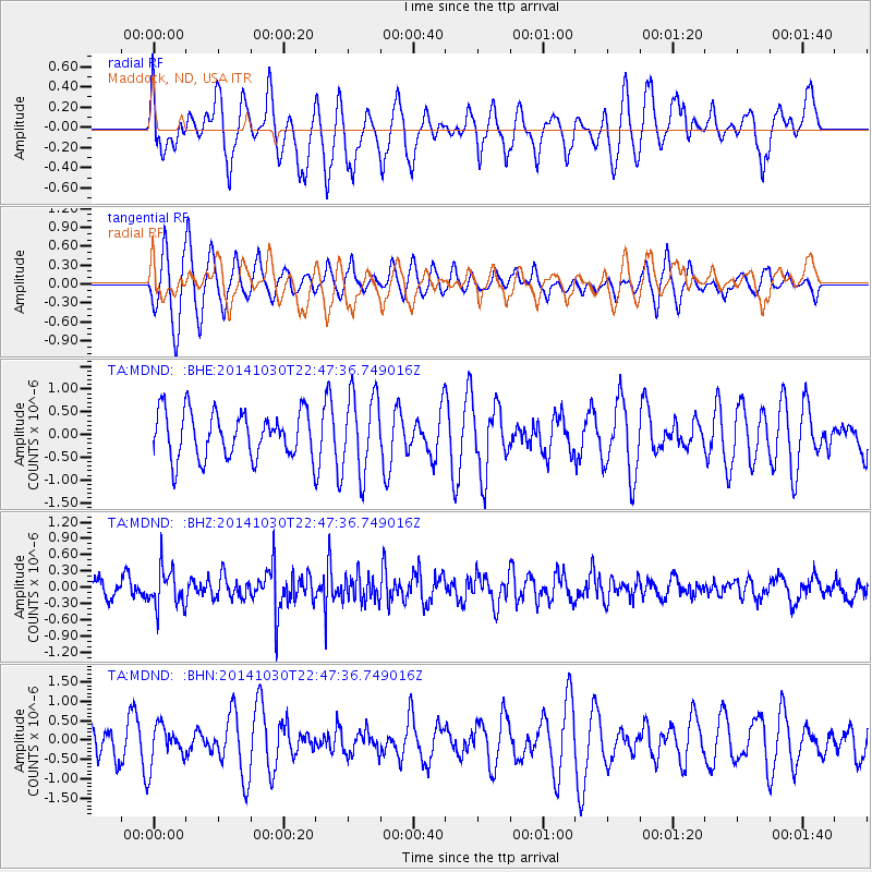
MDND Maddock, ND, USA - Earthquake Result Viewer
*The percent match for this event was below the threshold and hence no stack was calculated.
| Earthquake location: |
Near Coast Of Peru |
| Earthquake latitude/longitude: |
-16.2/-73.6 |
| Earthquake time(UTC): |
2014/10/30 (303) 22:37:15 GMT |
| Earthquake Depth: |
61 km |
| Earthquake Magnitude: |
5.1 MW |
| Earthquake Catalog/Contributor: |
ISC/ISC |
|
| Network: |
TA USArray Transportable Network (new EarthScope stations) |
| Station: |
MDND Maddock, ND, USA |
| Lat/Lon: |
47.85 N/99.60 W |
| Elevation: |
479 m |
|
| Distance: |
67.8 deg |
| Az: |
341.387 deg |
| Baz: |
152.911 deg |
| Ray Param: |
$rayparam |
*The percent match for this event was below the threshold and hence was not used in the summary stack. |
|
| Radial Match: |
63.24406 % |
| Radial Bump: |
400 |
| Transverse Match: |
73.72317 % |
| Transverse Bump: |
400 |
| SOD ConfigId: |
3390531 |
| Insert Time: |
2019-04-14 19:16:33.625 +0000 |
| GWidth: |
2.5 |
| Max Bumps: |
400 |
| Tol: |
0.001 |
|
Signal To Noise
| Channel | StoN | STA | LTA |
| TA:MDND: :BHZ:20141030T22:47:36.749016Z | 2.2623043 | 3.6316882E-7 | 1.6053049E-7 |
| TA:MDND: :BHN:20141030T22:47:36.749016Z | 1.2791713 | 5.0636237E-7 | 3.9585186E-7 |
| TA:MDND: :BHE:20141030T22:47:36.749016Z | 1.7160628 | 8.7039217E-7 | 5.0720297E-7 |
| Arrivals |
| Ps | |
| PpPs | |
| PsPs/PpSs | |


