You are here: Home > Network List > TA - USArray Transportable Network (new EarthScope stations) Stations List
> Station R11A Troy Canyon, Currant, NV, USA > Earthquake Result Viewer
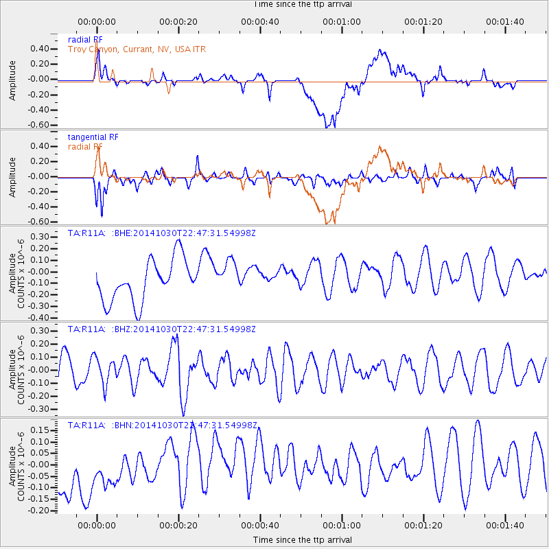
R11A Troy Canyon, Currant, NV, USA - Earthquake Result Viewer
*The percent match for this event was below the threshold and hence no stack was calculated.
| Earthquake location: |
Near Coast Of Peru |
| Earthquake latitude/longitude: |
-16.2/-73.6 |
| Earthquake time(UTC): |
2014/10/30 (303) 22:37:15 GMT |
| Earthquake Depth: |
61 km |
| Earthquake Magnitude: |
5.1 MW |
| Earthquake Catalog/Contributor: |
ISC/ISC |
|
| Network: |
TA USArray Transportable Network (new EarthScope stations) |
| Station: |
R11A Troy Canyon, Currant, NV, USA |
| Lat/Lon: |
38.35 N/115.59 W |
| Elevation: |
1756 m |
|
| Distance: |
67.0 deg |
| Az: |
325.135 deg |
| Baz: |
135.678 deg |
| Ray Param: |
$rayparam |
*The percent match for this event was below the threshold and hence was not used in the summary stack. |
|
| Radial Match: |
37.103466 % |
| Radial Bump: |
400 |
| Transverse Match: |
62.425377 % |
| Transverse Bump: |
400 |
| SOD ConfigId: |
3390531 |
| Insert Time: |
2019-04-14 19:16:43.301 +0000 |
| GWidth: |
2.5 |
| Max Bumps: |
400 |
| Tol: |
0.001 |
|
Signal To Noise
| Channel | StoN | STA | LTA |
| TA:R11A: :BHZ:20141030T22:47:31.54998Z | 0.9639232 | 1.01645675E-7 | 1.0544997E-7 |
| TA:R11A: :BHN:20141030T22:47:31.54998Z | 0.8387224 | 1.4247904E-7 | 1.6987627E-7 |
| TA:R11A: :BHE:20141030T22:47:31.54998Z | 0.77940685 | 1.3913032E-7 | 1.7850795E-7 |
| Arrivals |
| Ps | |
| PpPs | |
| PsPs/PpSs | |


