You are here: Home > Network List > TA - USArray Transportable Network (new EarthScope stations) Stations List
> Station Z41A Richland Creek Farm, El Dorado, AR, USA > Earthquake Result Viewer
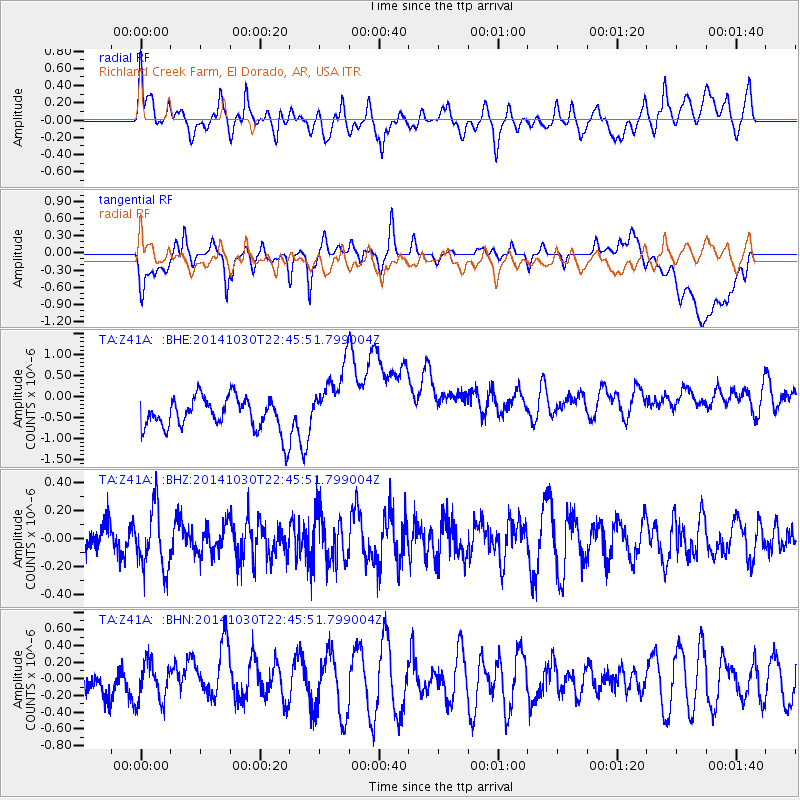
Z41A Richland Creek Farm, El Dorado, AR, USA - Earthquake Result Viewer
*The percent match for this event was below the threshold and hence no stack was calculated.
| Earthquake location: |
Near Coast Of Peru |
| Earthquake latitude/longitude: |
-16.2/-73.6 |
| Earthquake time(UTC): |
2014/10/30 (303) 22:37:15 GMT |
| Earthquake Depth: |
61 km |
| Earthquake Magnitude: |
5.1 MW |
| Earthquake Catalog/Contributor: |
ISC/ISC |
|
| Network: |
TA USArray Transportable Network (new EarthScope stations) |
| Station: |
Z41A Richland Creek Farm, El Dorado, AR, USA |
| Lat/Lon: |
33.26 N/92.80 W |
| Elevation: |
62 m |
|
| Distance: |
52.5 deg |
| Az: |
339.632 deg |
| Baz: |
156.472 deg |
| Ray Param: |
$rayparam |
*The percent match for this event was below the threshold and hence was not used in the summary stack. |
|
| Radial Match: |
43.900074 % |
| Radial Bump: |
400 |
| Transverse Match: |
27.879175 % |
| Transverse Bump: |
400 |
| SOD ConfigId: |
3390531 |
| Insert Time: |
2019-04-14 19:16:57.992 +0000 |
| GWidth: |
2.5 |
| Max Bumps: |
400 |
| Tol: |
0.001 |
|
Signal To Noise
| Channel | StoN | STA | LTA |
| TA:Z41A: :BHZ:20141030T22:45:51.799004Z | 1.7294519 | 2.2180494E-7 | 1.2825159E-7 |
| TA:Z41A: :BHN:20141030T22:45:51.799004Z | 1.2397355 | 2.3285014E-7 | 1.8782244E-7 |
| TA:Z41A: :BHE:20141030T22:45:51.799004Z | 2.0916395 | 8.044758E-7 | 3.8461494E-7 |
| Arrivals |
| Ps | |
| PpPs | |
| PsPs/PpSs | |


