You are here: Home > Network List > US - United States National Seismic Network Stations List
> Station WMOK Wichita Mountains, Oklahoma, USA > Earthquake Result Viewer
WMOK Wichita Mountains, Oklahoma, USA - Earthquake Result Viewer
*The percent match for this event was below the threshold and hence no stack was calculated.
| Earthquake location: |
Near Coast Of Peru |
| Earthquake latitude/longitude: |
-16.2/-73.6 |
| Earthquake time(UTC): |
2014/10/30 (303) 22:37:15 GMT |
| Earthquake Depth: |
61 km |
| Earthquake Magnitude: |
5.1 MW |
| Earthquake Catalog/Contributor: |
ISC/ISC |
|
| Network: |
US United States National Seismic Network |
| Station: |
WMOK Wichita Mountains, Oklahoma, USA |
| Lat/Lon: |
34.74 N/98.78 W |
| Elevation: |
486 m |
|
| Distance: |
56.0 deg |
| Az: |
334.97 deg |
| Baz: |
150.415 deg |
| Ray Param: |
$rayparam |
*The percent match for this event was below the threshold and hence was not used in the summary stack. |
|
| Radial Match: |
65.619774 % |
| Radial Bump: |
400 |
| Transverse Match: |
56.58674 % |
| Transverse Bump: |
400 |
| SOD ConfigId: |
3390531 |
| Insert Time: |
2019-04-14 19:17:30.684 +0000 |
| GWidth: |
2.5 |
| Max Bumps: |
400 |
| Tol: |
0.001 |
|
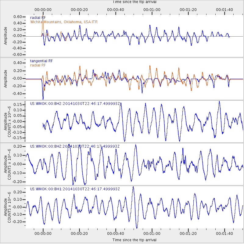
Signal To Noise
| Channel | StoN | STA | LTA |
| US:WMOK:00:BHZ:20141030T22:46:17.499993Z | 0.78251815 | 6.051059E-8 | 7.732803E-8 |
| US:WMOK:00:BH1:20141030T22:46:17.499993Z | 2.08951 | 1.3239408E-7 | 6.3361306E-8 |
| US:WMOK:00:BH2:20141030T22:46:17.499993Z | 0.69162595 | 3.1801395E-8 | 4.5980627E-8 |
| Arrivals |
| Ps | |
| PpPs | |
| PsPs/PpSs | |


