You are here: Home > Network List > IW - Intermountain West Stations List
> Station MOOW Moose Ponds, Wyoming, USA > Earthquake Result Viewer
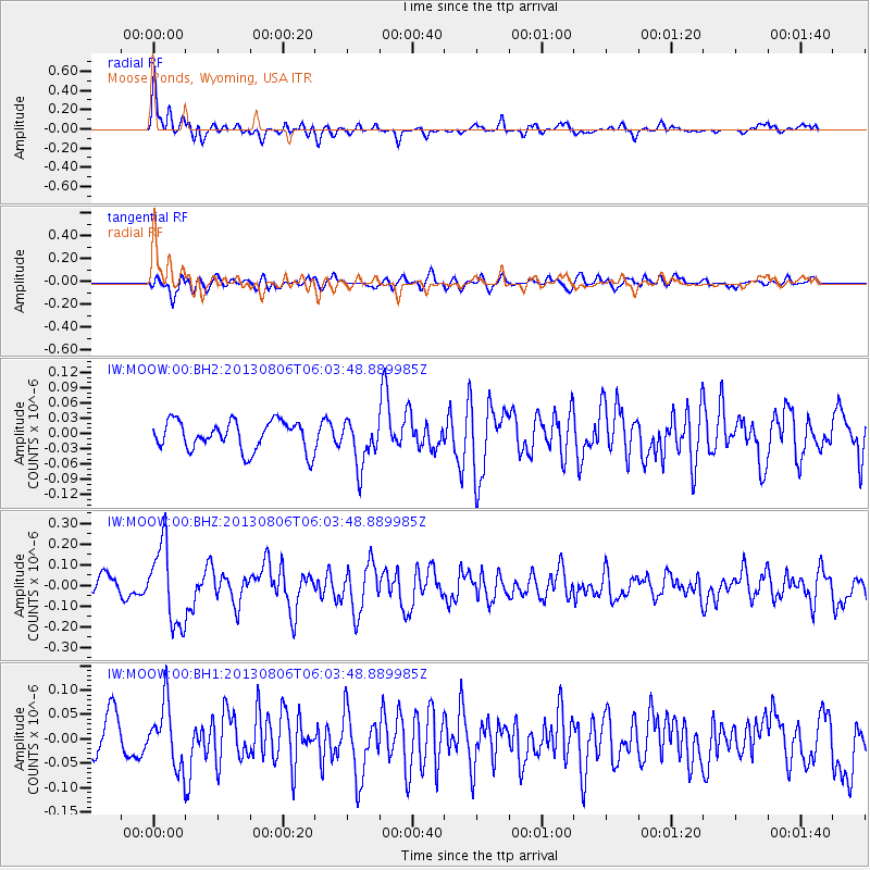
MOOW Moose Ponds, Wyoming, USA - Earthquake Result Viewer
*The percent match for this event was below the threshold and hence no stack was calculated.
| Earthquake location: |
Guatemala |
| Earthquake latitude/longitude: |
14.2/-91.6 |
| Earthquake time(UTC): |
2013/08/06 (218) 05:57:42 GMT |
| Earthquake Depth: |
54 km |
| Earthquake Magnitude: |
5.5 MW, 5.5 MWC, 5.6 MWB |
| Earthquake Catalog/Contributor: |
NEIC PDE/NEIC COMCAT |
|
| Network: |
IW Intermountain West |
| Station: |
MOOW Moose Ponds, Wyoming, USA |
| Lat/Lon: |
43.75 N/110.74 W |
| Elevation: |
2128 m |
|
| Distance: |
33.7 deg |
| Az: |
334.664 deg |
| Baz: |
145.055 deg |
| Ray Param: |
$rayparam |
*The percent match for this event was below the threshold and hence was not used in the summary stack. |
|
| Radial Match: |
70.45409 % |
| Radial Bump: |
400 |
| Transverse Match: |
66.43534 % |
| Transverse Bump: |
400 |
| SOD ConfigId: |
626651 |
| Insert Time: |
2014-04-17 19:08:38.022 +0000 |
| GWidth: |
2.5 |
| Max Bumps: |
400 |
| Tol: |
0.001 |
|
Signal To Noise
| Channel | StoN | STA | LTA |
| IW:MOOW:00:BHZ:20130806T06:03:48.889985Z | 3.0053453 | 1.9066427E-7 | 6.344172E-8 |
| IW:MOOW:00:BH1:20130806T06:03:48.889985Z | 1.2983357 | 6.322609E-8 | 4.86978E-8 |
| IW:MOOW:00:BH2:20130806T06:03:48.889985Z | 1.5641303 | 4.460705E-8 | 2.8518755E-8 |
| Arrivals |
| Ps | |
| PpPs | |
| PsPs/PpSs | |


