You are here: Home > Network List > TA - USArray Transportable Network (new EarthScope stations) Stations List
> Station D41A Chassel, MI, USA > Earthquake Result Viewer
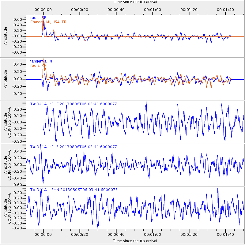
D41A Chassel, MI, USA - Earthquake Result Viewer
*The percent match for this event was below the threshold and hence no stack was calculated.
| Earthquake location: |
Guatemala |
| Earthquake latitude/longitude: |
14.2/-91.6 |
| Earthquake time(UTC): |
2013/08/06 (218) 05:57:42 GMT |
| Earthquake Depth: |
54 km |
| Earthquake Magnitude: |
5.5 MW, 5.5 MWC, 5.6 MWB |
| Earthquake Catalog/Contributor: |
NEIC PDE/NEIC COMCAT |
|
| Network: |
TA USArray Transportable Network (new EarthScope stations) |
| Station: |
D41A Chassel, MI, USA |
| Lat/Lon: |
47.06 N/88.57 W |
| Elevation: |
271 m |
|
| Distance: |
32.9 deg |
| Az: |
3.814 deg |
| Baz: |
185.416 deg |
| Ray Param: |
$rayparam |
*The percent match for this event was below the threshold and hence was not used in the summary stack. |
|
| Radial Match: |
60.521538 % |
| Radial Bump: |
400 |
| Transverse Match: |
53.85537 % |
| Transverse Bump: |
400 |
| SOD ConfigId: |
626651 |
| Insert Time: |
2014-04-17 19:14:05.771 +0000 |
| GWidth: |
2.5 |
| Max Bumps: |
400 |
| Tol: |
0.001 |
|
Signal To Noise
| Channel | StoN | STA | LTA |
| TA:D41A: :BHZ:20130806T06:03:41.600007Z | 2.0253928 | 2.1152759E-7 | 1.0443782E-7 |
| TA:D41A: :BHN:20130806T06:03:41.600007Z | 1.5861678 | 1.5997318E-7 | 1.0085515E-7 |
| TA:D41A: :BHE:20130806T06:03:41.600007Z | 0.8726717 | 1.171693E-7 | 1.3426504E-7 |
| Arrivals |
| Ps | |
| PpPs | |
| PsPs/PpSs | |


