You are here: Home > Network List > TA - USArray Transportable Network (new EarthScope stations) Stations List
> Station N60A Cedar Hill Farm, Mount Bethel, PA, USA > Earthquake Result Viewer
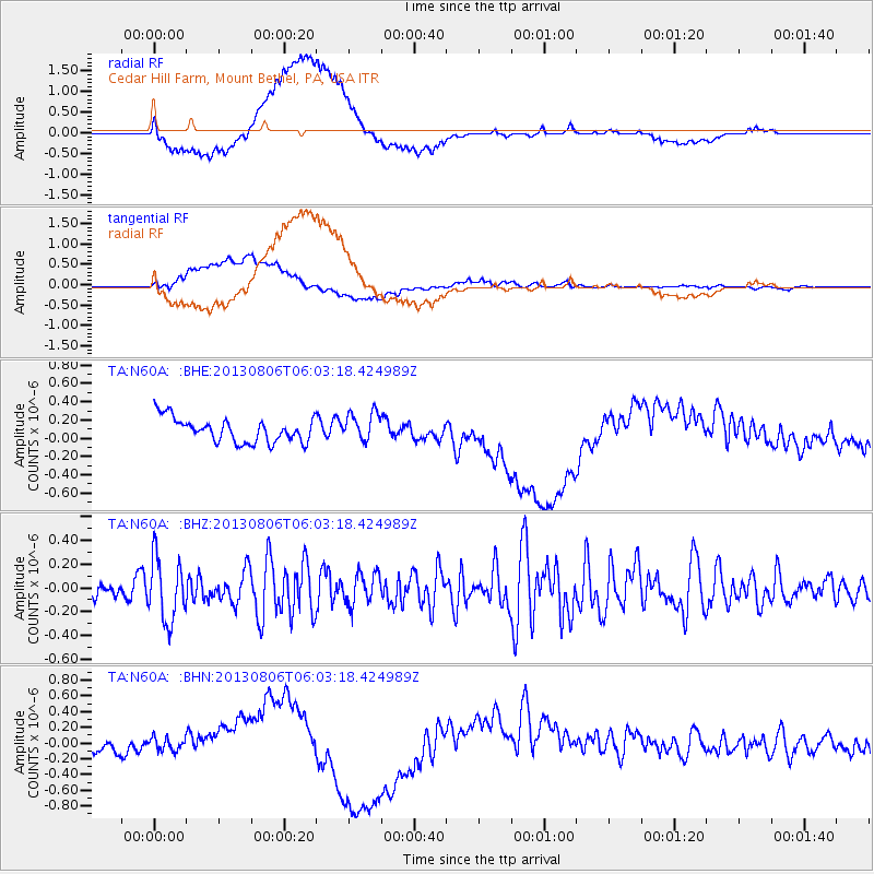
N60A Cedar Hill Farm, Mount Bethel, PA, USA - Earthquake Result Viewer
*The percent match for this event was below the threshold and hence no stack was calculated.
| Earthquake location: |
Guatemala |
| Earthquake latitude/longitude: |
14.2/-91.6 |
| Earthquake time(UTC): |
2013/08/06 (218) 05:57:42 GMT |
| Earthquake Depth: |
54 km |
| Earthquake Magnitude: |
5.5 MW, 5.5 MWC, 5.6 MWB |
| Earthquake Catalog/Contributor: |
NEIC PDE/NEIC COMCAT |
|
| Network: |
TA USArray Transportable Network (new EarthScope stations) |
| Station: |
N60A Cedar Hill Farm, Mount Bethel, PA, USA |
| Lat/Lon: |
40.87 N/75.10 W |
| Elevation: |
189 m |
|
| Distance: |
30.3 deg |
| Az: |
25.296 deg |
| Baz: |
213.131 deg |
| Ray Param: |
$rayparam |
*The percent match for this event was below the threshold and hence was not used in the summary stack. |
|
| Radial Match: |
61.880295 % |
| Radial Bump: |
400 |
| Transverse Match: |
49.135746 % |
| Transverse Bump: |
400 |
| SOD ConfigId: |
626651 |
| Insert Time: |
2014-04-17 19:18:10.020 +0000 |
| GWidth: |
2.5 |
| Max Bumps: |
400 |
| Tol: |
0.001 |
|
Signal To Noise
| Channel | StoN | STA | LTA |
| TA:N60A: :BHZ:20130806T06:03:18.424989Z | 2.87176 | 2.619002E-7 | 9.11985E-8 |
| TA:N60A: :BHN:20130806T06:03:18.424989Z | 0.7476688 | 8.3472074E-8 | 1.1164311E-7 |
| TA:N60A: :BHE:20130806T06:03:18.424989Z | 1.1985248 | 1.5811477E-7 | 1.3192448E-7 |
| Arrivals |
| Ps | |
| PpPs | |
| PsPs/PpSs | |


