You are here: Home > Network List > US - United States National Seismic Network Stations List
> Station MSO Missoula, Montana, USA > Earthquake Result Viewer
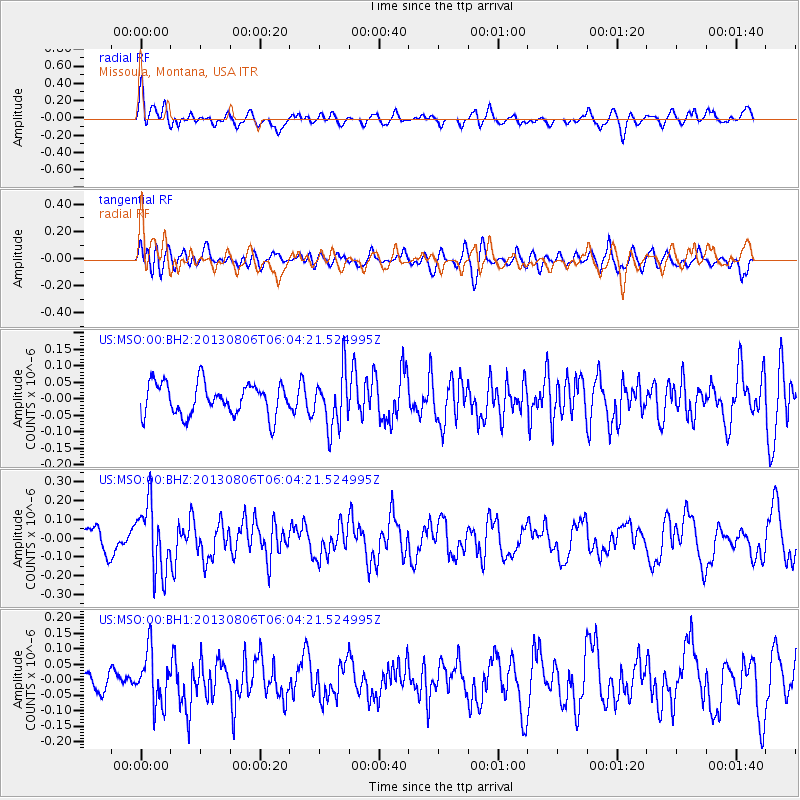
MSO Missoula, Montana, USA - Earthquake Result Viewer
*The percent match for this event was below the threshold and hence no stack was calculated.
| Earthquake location: |
Guatemala |
| Earthquake latitude/longitude: |
14.2/-91.6 |
| Earthquake time(UTC): |
2013/08/06 (218) 05:57:42 GMT |
| Earthquake Depth: |
54 km |
| Earthquake Magnitude: |
5.5 MW, 5.5 MWC, 5.6 MWB |
| Earthquake Catalog/Contributor: |
NEIC PDE/NEIC COMCAT |
|
| Network: |
US United States National Seismic Network |
| Station: |
MSO Missoula, Montana, USA |
| Lat/Lon: |
46.83 N/113.94 W |
| Elevation: |
1264 m |
|
| Distance: |
37.6 deg |
| Az: |
334.648 deg |
| Baz: |
142.777 deg |
| Ray Param: |
$rayparam |
*The percent match for this event was below the threshold and hence was not used in the summary stack. |
|
| Radial Match: |
68.33287 % |
| Radial Bump: |
400 |
| Transverse Match: |
52.120953 % |
| Transverse Bump: |
400 |
| SOD ConfigId: |
626651 |
| Insert Time: |
2014-04-17 19:19:22.030 +0000 |
| GWidth: |
2.5 |
| Max Bumps: |
400 |
| Tol: |
0.001 |
|
Signal To Noise
| Channel | StoN | STA | LTA |
| US:MSO:00:BHZ:20130806T06:04:21.524995Z | 2.1480844 | 1.8131433E-7 | 8.440745E-8 |
| US:MSO:00:BH1:20130806T06:04:21.524995Z | 2.4682891 | 8.420209E-8 | 3.4113548E-8 |
| US:MSO:00:BH2:20130806T06:04:21.524995Z | 1.7084599 | 8.243926E-8 | 4.825355E-8 |
| Arrivals |
| Ps | |
| PpPs | |
| PsPs/PpSs | |


