You are here: Home > Network List > TA - USArray Transportable Network (new EarthScope stations) Stations List
> Station MSTX Muleshoe, TX, USA > Earthquake Result Viewer
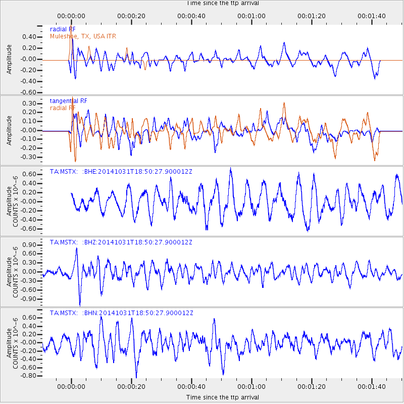
MSTX Muleshoe, TX, USA - Earthquake Result Viewer
*The percent match for this event was below the threshold and hence no stack was calculated.
| Earthquake location: |
Northern Peru |
| Earthquake latitude/longitude: |
-7.6/-76.4 |
| Earthquake time(UTC): |
2014/10/31 (304) 18:42:17 GMT |
| Earthquake Depth: |
10 km |
| Earthquake Magnitude: |
5.2 MW |
| Earthquake Catalog/Contributor: |
ISC/ISC |
|
| Network: |
TA USArray Transportable Network (new EarthScope stations) |
| Station: |
MSTX Muleshoe, TX, USA |
| Lat/Lon: |
33.97 N/102.77 W |
| Elevation: |
1167 m |
|
| Distance: |
48.3 deg |
| Az: |
330.395 deg |
| Baz: |
143.896 deg |
| Ray Param: |
$rayparam |
*The percent match for this event was below the threshold and hence was not used in the summary stack. |
|
| Radial Match: |
42.93064 % |
| Radial Bump: |
400 |
| Transverse Match: |
48.741257 % |
| Transverse Bump: |
400 |
| SOD ConfigId: |
3390531 |
| Insert Time: |
2019-04-14 19:26:03.131 +0000 |
| GWidth: |
2.5 |
| Max Bumps: |
400 |
| Tol: |
0.001 |
|
Signal To Noise
| Channel | StoN | STA | LTA |
| TA:MSTX: :BHZ:20141031T18:50:27.900012Z | 3.1315813 | 4.2178002E-7 | 1.3468595E-7 |
| TA:MSTX: :BHN:20141031T18:50:27.900012Z | 0.9988398 | 2.1222188E-7 | 2.1246838E-7 |
| TA:MSTX: :BHE:20141031T18:50:27.900012Z | 1.2306101 | 2.2970049E-7 | 1.8665578E-7 |
| Arrivals |
| Ps | |
| PpPs | |
| PsPs/PpSs | |


