You are here: Home > Network List > UW - Pacific Northwest Regional Seismic Network Stations List
> Station HOOD Mt Hood Meadows, OR CREST BB SMO > Earthquake Result Viewer
HOOD Mt Hood Meadows, OR CREST BB SMO - Earthquake Result Viewer

| Earthquake location: |
Guatemala |
| Earthquake latitude/longitude: |
14.2/-91.6 |
| Earthquake time(UTC): |
2013/08/06 (218) 05:57:42 GMT |
| Earthquake Depth: |
54 km |
| Earthquake Magnitude: |
5.5 MW, 5.5 MWC, 5.6 MWB |
| Earthquake Catalog/Contributor: |
NEIC PDE/NEIC COMCAT |
|
| Network: |
UW Pacific Northwest Regional Seismic Network |
| Station: |
HOOD Mt Hood Meadows, OR CREST BB SMO |
| Lat/Lon: |
45.32 N/121.65 W |
| Elevation: |
1520 m |
|
| Distance: |
40.1 deg |
| Az: |
326.756 deg |
| Baz: |
131.084 deg |
| Ray Param: |
0.07443237 |
| Estimated Moho Depth: |
63.75 km |
| Estimated Crust Vp/Vs: |
2.06 |
| Assumed Crust Vp: |
6.597 km/s |
| Estimated Crust Vs: |
3.21 km/s |
| Estimated Crust Poisson's Ratio: |
0.34 |
|
| Radial Match: |
87.02351 % |
| Radial Bump: |
400 |
| Transverse Match: |
76.71679 % |
| Transverse Bump: |
400 |
| SOD ConfigId: |
626651 |
| Insert Time: |
2014-04-17 19:20:54.407 +0000 |
| GWidth: |
2.5 |
| Max Bumps: |
400 |
| Tol: |
0.001 |
|
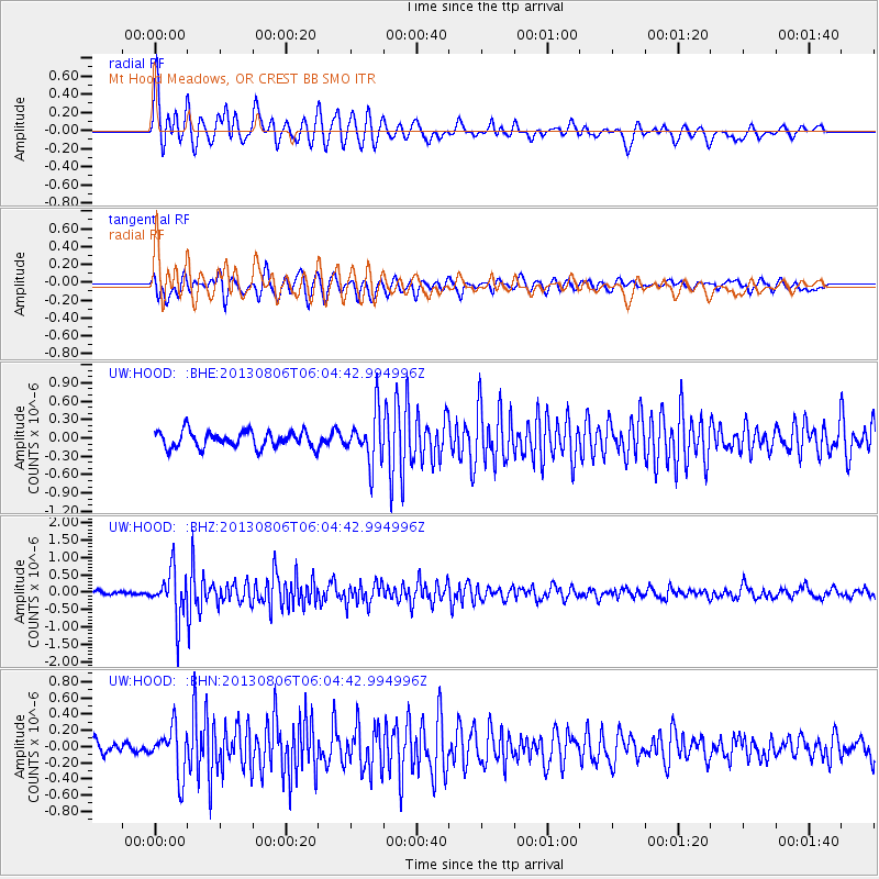
Signal To Noise
| Channel | StoN | STA | LTA |
| UW:HOOD: :BHZ:20130806T06:04:42.994996Z | 11.764676 | 6.848807E-7 | 5.8215008E-8 |
| UW:HOOD: :BHN:20130806T06:04:42.994996Z | 3.231031 | 2.8435105E-7 | 8.8006296E-8 |
| UW:HOOD: :BHE:20130806T06:04:42.994996Z | 3.0464838 | 4.0902088E-7 | 1.3426E-7 |
| Arrivals |
| Ps | 11 SECOND |
| PpPs | 28 SECOND |
| PsPs/PpSs | 39 SECOND |


