You are here: Home > Network List > UW - Pacific Northwest Regional Seismic Network Stations List
> Station LEBA Lebam, WA, USA > Earthquake Result Viewer
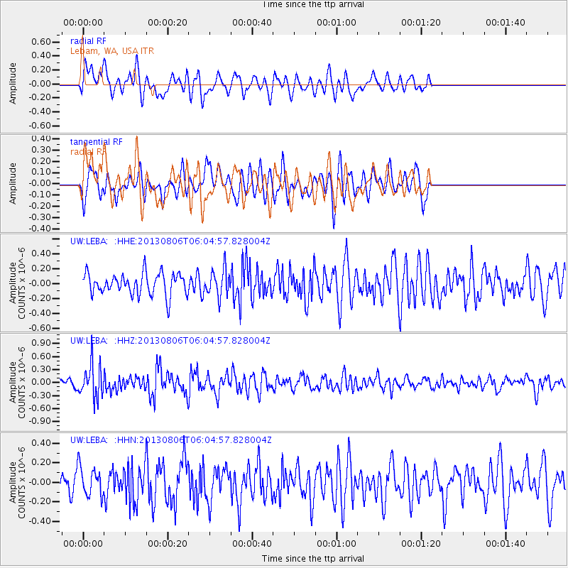
LEBA Lebam, WA, USA - Earthquake Result Viewer
*The percent match for this event was below the threshold and hence no stack was calculated.
| Earthquake location: |
Guatemala |
| Earthquake latitude/longitude: |
14.2/-91.6 |
| Earthquake time(UTC): |
2013/08/06 (218) 05:57:42 GMT |
| Earthquake Depth: |
54 km |
| Earthquake Magnitude: |
5.5 MW, 5.5 MWC, 5.6 MWB |
| Earthquake Catalog/Contributor: |
NEIC PDE/NEIC COMCAT |
|
| Network: |
UW Pacific Northwest Regional Seismic Network |
| Station: |
LEBA Lebam, WA, USA |
| Lat/Lon: |
46.55 N/123.56 W |
| Elevation: |
73 m |
|
| Distance: |
41.9 deg |
| Az: |
326.859 deg |
| Baz: |
129.793 deg |
| Ray Param: |
$rayparam |
*The percent match for this event was below the threshold and hence was not used in the summary stack. |
|
| Radial Match: |
59.470196 % |
| Radial Bump: |
400 |
| Transverse Match: |
67.46962 % |
| Transverse Bump: |
400 |
| SOD ConfigId: |
626651 |
| Insert Time: |
2014-04-17 19:21:07.548 +0000 |
| GWidth: |
2.5 |
| Max Bumps: |
400 |
| Tol: |
0.001 |
|
Signal To Noise
| Channel | StoN | STA | LTA |
| UW:LEBA: :HHZ:20130806T06:04:57.828004Z | 3.1941879 | 3.9098467E-7 | 1.2240503E-7 |
| UW:LEBA: :HHN:20130806T06:04:57.828004Z | 0.90437037 | 1.4030208E-7 | 1.5513785E-7 |
| UW:LEBA: :HHE:20130806T06:04:57.828004Z | 1.2707646 | 1.8120508E-7 | 1.4259531E-7 |
| Arrivals |
| Ps | |
| PpPs | |
| PsPs/PpSs | |


