You are here: Home > Network List > BK - Berkeley Digital Seismograph Network Stations List
> Station HUMO Hull Mountain, OR > Earthquake Result Viewer
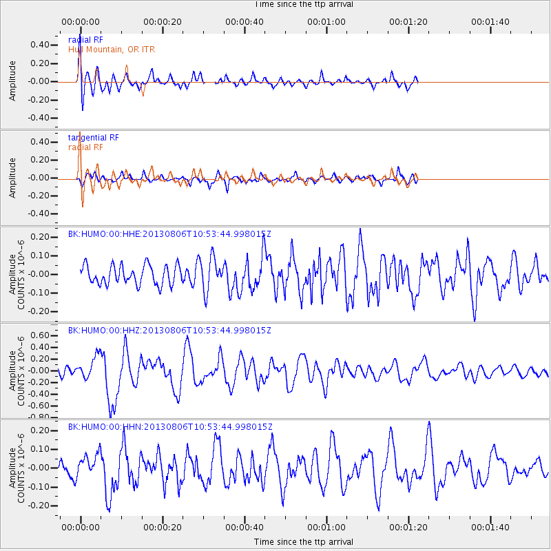
HUMO Hull Mountain, OR - Earthquake Result Viewer
*The percent match for this event was below the threshold and hence no stack was calculated.
| Earthquake location: |
Southeast Of Loyalty Islands |
| Earthquake latitude/longitude: |
-22.5/173.8 |
| Earthquake time(UTC): |
2013/08/06 (218) 10:41:30 GMT |
| Earthquake Depth: |
10 km |
| Earthquake Magnitude: |
5.8 MWW, 5.8 MWB, 5.9 MWC |
| Earthquake Catalog/Contributor: |
NEIC PDE/NEIC COMCAT |
|
| Network: |
BK Berkeley Digital Seismograph Network |
| Station: |
HUMO Hull Mountain, OR |
| Lat/Lon: |
42.61 N/122.96 W |
| Elevation: |
555 m |
|
| Distance: |
87.1 deg |
| Az: |
41.303 deg |
| Baz: |
235.768 deg |
| Ray Param: |
$rayparam |
*The percent match for this event was below the threshold and hence was not used in the summary stack. |
|
| Radial Match: |
78.108086 % |
| Radial Bump: |
400 |
| Transverse Match: |
68.036804 % |
| Transverse Bump: |
374 |
| SOD ConfigId: |
626651 |
| Insert Time: |
2014-04-17 19:29:32.055 +0000 |
| GWidth: |
2.5 |
| Max Bumps: |
400 |
| Tol: |
0.001 |
|
Signal To Noise
| Channel | StoN | STA | LTA |
| BK:HUMO:00:HHZ:20130806T10:53:44.998015Z | 4.060475 | 1.9562398E-7 | 4.8177615E-8 |
| BK:HUMO:00:HHN:20130806T10:53:44.998015Z | 1.431041 | 5.947632E-8 | 4.1561577E-8 |
| BK:HUMO:00:HHE:20130806T10:53:44.998015Z | 1.7705269 | 8.928498E-8 | 5.0428483E-8 |
| Arrivals |
| Ps | |
| PpPs | |
| PsPs/PpSs | |


