You are here: Home > Network List > G - GEOSCOPE Stations List
> Station INU Inuyama, Japan > Earthquake Result Viewer
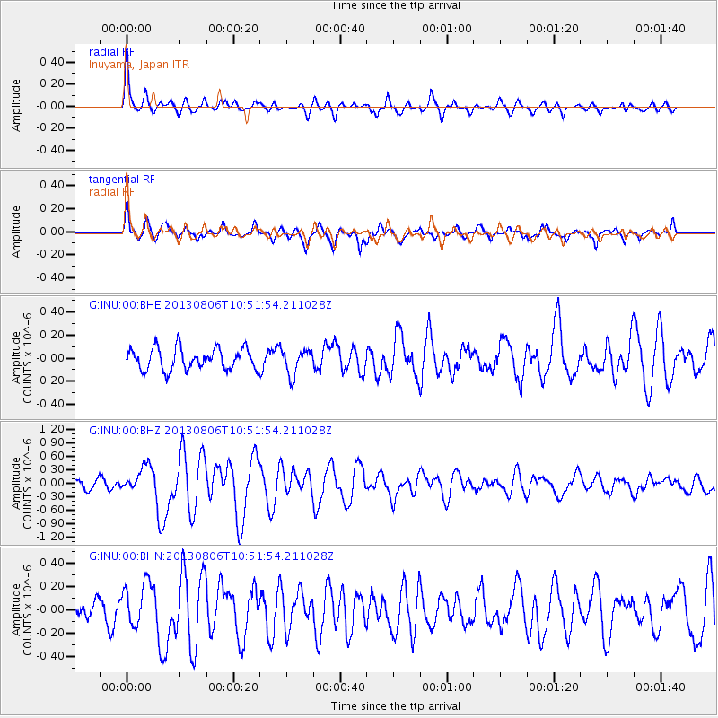
INU Inuyama, Japan - Earthquake Result Viewer
*The percent match for this event was below the threshold and hence no stack was calculated.
| Earthquake location: |
Southeast Of Loyalty Islands |
| Earthquake latitude/longitude: |
-22.5/173.8 |
| Earthquake time(UTC): |
2013/08/06 (218) 10:41:30 GMT |
| Earthquake Depth: |
10 km |
| Earthquake Magnitude: |
5.8 MWW, 5.8 MWB, 5.9 MWC |
| Earthquake Catalog/Contributor: |
NEIC PDE/NEIC COMCAT |
|
| Network: |
G GEOSCOPE |
| Station: |
INU Inuyama, Japan |
| Lat/Lon: |
35.35 N/137.03 E |
| Elevation: |
132 m |
|
| Distance: |
67.3 deg |
| Az: |
327.954 deg |
| Baz: |
143.113 deg |
| Ray Param: |
$rayparam |
*The percent match for this event was below the threshold and hence was not used in the summary stack. |
|
| Radial Match: |
82.37605 % |
| Radial Bump: |
400 |
| Transverse Match: |
73.384636 % |
| Transverse Bump: |
400 |
| SOD ConfigId: |
626651 |
| Insert Time: |
2014-04-17 19:32:07.839 +0000 |
| GWidth: |
2.5 |
| Max Bumps: |
400 |
| Tol: |
0.001 |
|
Signal To Noise
| Channel | StoN | STA | LTA |
| G:INU:00:BHZ:20130806T10:51:54.211028Z | 2.7375455 | 2.94857E-7 | 1.0770852E-7 |
| G:INU:00:BHN:20130806T10:51:54.211028Z | 2.3809972 | 1.9149857E-7 | 8.042788E-8 |
| G:INU:00:BHE:20130806T10:51:54.211028Z | 1.2025545 | 1.1056565E-7 | 9.194232E-8 |
| Arrivals |
| Ps | |
| PpPs | |
| PsPs/PpSs | |


