You are here: Home > Network List > TA - USArray Transportable Network (new EarthScope stations) Stations List
> Station H04D Lebanon, OR, USA > Earthquake Result Viewer
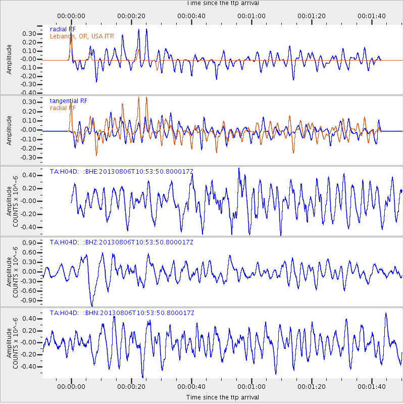
H04D Lebanon, OR, USA - Earthquake Result Viewer
*The percent match for this event was below the threshold and hence no stack was calculated.
| Earthquake location: |
Southeast Of Loyalty Islands |
| Earthquake latitude/longitude: |
-22.5/173.8 |
| Earthquake time(UTC): |
2013/08/06 (218) 10:41:30 GMT |
| Earthquake Depth: |
10 km |
| Earthquake Magnitude: |
5.8 MWW, 5.8 MWB, 5.9 MWC |
| Earthquake Catalog/Contributor: |
NEIC PDE/NEIC COMCAT |
|
| Network: |
TA USArray Transportable Network (new EarthScope stations) |
| Station: |
H04D Lebanon, OR, USA |
| Lat/Lon: |
44.52 N/122.74 W |
| Elevation: |
284 m |
|
| Distance: |
88.3 deg |
| Az: |
39.807 deg |
| Baz: |
235.859 deg |
| Ray Param: |
$rayparam |
*The percent match for this event was below the threshold and hence was not used in the summary stack. |
|
| Radial Match: |
66.88798 % |
| Radial Bump: |
400 |
| Transverse Match: |
54.46829 % |
| Transverse Bump: |
400 |
| SOD ConfigId: |
626651 |
| Insert Time: |
2014-04-17 19:37:25.840 +0000 |
| GWidth: |
2.5 |
| Max Bumps: |
400 |
| Tol: |
0.001 |
|
Signal To Noise
| Channel | StoN | STA | LTA |
| TA:H04D: :BHZ:20130806T10:53:50.800017Z | 1.9610995 | 2.6799768E-7 | 1.3665684E-7 |
| TA:H04D: :BHN:20130806T10:53:50.800017Z | 0.62165874 | 8.866579E-8 | 1.4262775E-7 |
| TA:H04D: :BHE:20130806T10:53:50.800017Z | 0.88885206 | 1.3629457E-7 | 1.5333774E-7 |
| Arrivals |
| Ps | |
| PpPs | |
| PsPs/PpSs | |


