You are here: Home > Network List > UW - Pacific Northwest Regional Seismic Network Stations List
> Station LTY Liberty (broad-band) > Earthquake Result Viewer
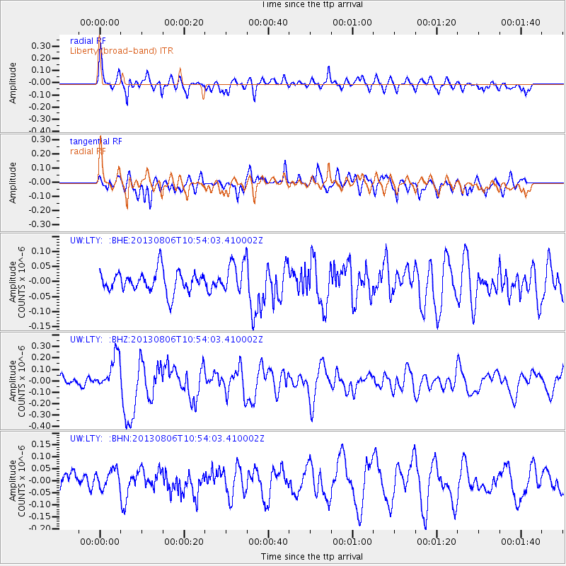
LTY Liberty (broad-band) - Earthquake Result Viewer
*The percent match for this event was below the threshold and hence no stack was calculated.
| Earthquake location: |
Southeast Of Loyalty Islands |
| Earthquake latitude/longitude: |
-22.5/173.8 |
| Earthquake time(UTC): |
2013/08/06 (218) 10:41:30 GMT |
| Earthquake Depth: |
10 km |
| Earthquake Magnitude: |
5.8 MWW, 5.8 MWB, 5.9 MWC |
| Earthquake Catalog/Contributor: |
NEIC PDE/NEIC COMCAT |
|
| Network: |
UW Pacific Northwest Regional Seismic Network |
| Station: |
LTY Liberty (broad-band) |
| Lat/Lon: |
47.26 N/120.66 W |
| Elevation: |
970 m |
|
| Distance: |
91.0 deg |
| Az: |
38.323 deg |
| Baz: |
237.334 deg |
| Ray Param: |
$rayparam |
*The percent match for this event was below the threshold and hence was not used in the summary stack. |
|
| Radial Match: |
71.536354 % |
| Radial Bump: |
400 |
| Transverse Match: |
66.08077 % |
| Transverse Bump: |
400 |
| SOD ConfigId: |
626651 |
| Insert Time: |
2014-04-17 19:41:07.438 +0000 |
| GWidth: |
2.5 |
| Max Bumps: |
400 |
| Tol: |
0.001 |
|
Signal To Noise
| Channel | StoN | STA | LTA |
| UW:LTY: :BHZ:20130806T10:54:03.410002Z | 2.6974645 | 1.567306E-7 | 5.8102934E-8 |
| UW:LTY: :BHN:20130806T10:54:03.410002Z | 1.0564272 | 4.1188812E-8 | 3.8988784E-8 |
| UW:LTY: :BHE:20130806T10:54:03.410002Z | 1.5852004 | 5.482603E-8 | 3.4586183E-8 |
| Arrivals |
| Ps | |
| PpPs | |
| PsPs/PpSs | |


