You are here: Home > Network List > UW - Pacific Northwest Regional Seismic Network Stations List
> Station LEBA Lebam, WA, USA > Earthquake Result Viewer
LEBA Lebam, WA, USA - Earthquake Result Viewer
*The percent match for this event was below the threshold and hence no stack was calculated.
| Earthquake location: |
Easter Island Region |
| Earthquake latitude/longitude: |
-31.9/-111.1 |
| Earthquake time(UTC): |
2014/11/01 (305) 10:05:43 GMT |
| Earthquake Depth: |
10 km |
| Earthquake Magnitude: |
5.8 MWW, 5.6 MWB, 5.7 MWC |
| Earthquake Catalog/Contributor: |
NEIC PDE/NEIC COMCAT |
|
| Network: |
UW Pacific Northwest Regional Seismic Network |
| Station: |
LEBA Lebam, WA, USA |
| Lat/Lon: |
46.55 N/123.56 W |
| Elevation: |
73 m |
|
| Distance: |
78.9 deg |
| Az: |
351.274 deg |
| Baz: |
169.227 deg |
| Ray Param: |
$rayparam |
*The percent match for this event was below the threshold and hence was not used in the summary stack. |
|
| Radial Match: |
60.55587 % |
| Radial Bump: |
400 |
| Transverse Match: |
63.00687 % |
| Transverse Bump: |
400 |
| SOD ConfigId: |
3390531 |
| Insert Time: |
2019-04-14 19:35:51.160 +0000 |
| GWidth: |
2.5 |
| Max Bumps: |
400 |
| Tol: |
0.001 |
|
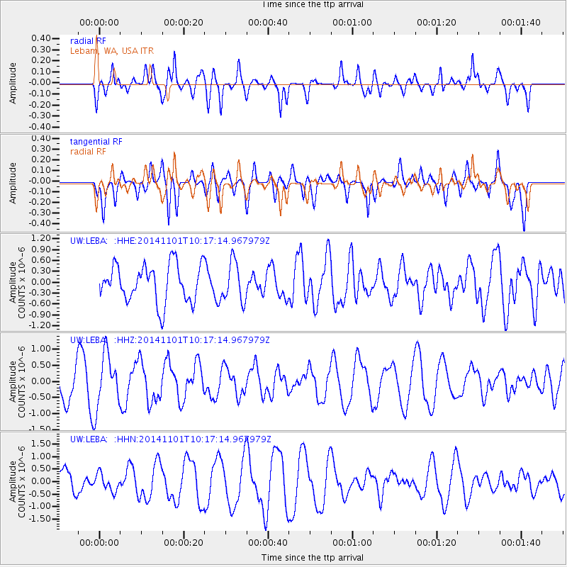
Signal To Noise
| Channel | StoN | STA | LTA |
| UW:LEBA: :HHZ:20141101T10:17:14.967979Z | 1.7688143 | 7.5807617E-7 | 4.2857874E-7 |
| UW:LEBA: :HHN:20141101T10:17:14.967979Z | 0.58405197 | 3.5102082E-7 | 6.010096E-7 |
| UW:LEBA: :HHE:20141101T10:17:14.967979Z | 1.0257956 | 5.3319354E-7 | 5.197853E-7 |
| Arrivals |
| Ps | |
| PpPs | |
| PsPs/PpSs | |


