You are here: Home > Network List > TA - USArray Transportable Network (new EarthScope stations) Stations List
> Station H17A Grant Village (NPS), Yellowstone Nt. Park, WY, USA > Earthquake Result Viewer
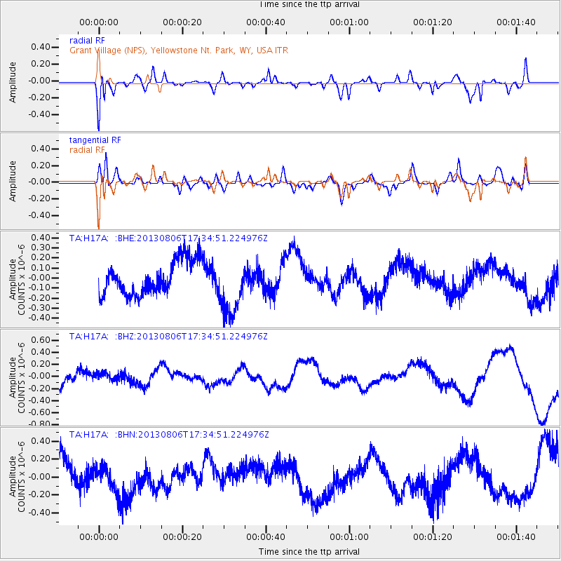
H17A Grant Village (NPS), Yellowstone Nt. Park, WY, USA - Earthquake Result Viewer
*The percent match for this event was below the threshold and hence no stack was calculated.
| Earthquake location: |
Vanuatu Islands |
| Earthquake latitude/longitude: |
-16.9/167.4 |
| Earthquake time(UTC): |
2013/08/06 (218) 17:21:55 GMT |
| Earthquake Depth: |
14 km |
| Earthquake Magnitude: |
5.7 MW, 5.7 MWW, 5.7 MWC, 5.7 MWW |
| Earthquake Catalog/Contributor: |
NEIC PDE/NEIC COMCAT |
|
| Network: |
TA USArray Transportable Network (new EarthScope stations) |
| Station: |
H17A Grant Village (NPS), Yellowstone Nt. Park, WY, USA |
| Lat/Lon: |
44.40 N/110.58 W |
| Elevation: |
2400 m |
|
| Distance: |
96.1 deg |
| Az: |
45.566 deg |
| Baz: |
252.469 deg |
| Ray Param: |
$rayparam |
*The percent match for this event was below the threshold and hence was not used in the summary stack. |
|
| Radial Match: |
77.421234 % |
| Radial Bump: |
400 |
| Transverse Match: |
61.367146 % |
| Transverse Bump: |
400 |
| SOD ConfigId: |
626651 |
| Insert Time: |
2014-04-17 20:17:05.678 +0000 |
| GWidth: |
2.5 |
| Max Bumps: |
400 |
| Tol: |
0.001 |
|
Signal To Noise
| Channel | StoN | STA | LTA |
| TA:H17A: :BHZ:20130806T17:34:51.224976Z | 0.39464244 | 7.078559E-8 | 1.793664E-7 |
| TA:H17A: :BHN:20130806T17:34:51.224976Z | 0.8992019 | 1.3682336E-7 | 1.521609E-7 |
| TA:H17A: :BHE:20130806T17:34:51.224976Z | 1.7651731 | 2.948146E-7 | 1.6701739E-7 |
| Arrivals |
| Ps | |
| PpPs | |
| PsPs/PpSs | |


