You are here: Home > Network List > TA - USArray Transportable Network (new EarthScope stations) Stations List
> Station O03E Paynes Creek, CA, USA > Earthquake Result Viewer
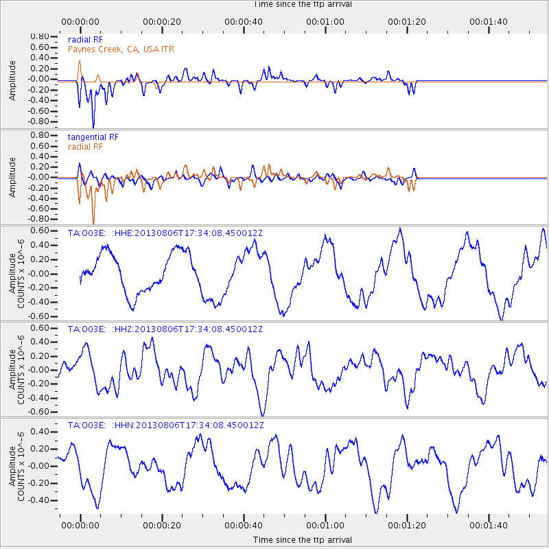
O03E Paynes Creek, CA, USA - Earthquake Result Viewer
*The percent match for this event was below the threshold and hence no stack was calculated.
| Earthquake location: |
Vanuatu Islands |
| Earthquake latitude/longitude: |
-16.9/167.4 |
| Earthquake time(UTC): |
2013/08/06 (218) 17:21:55 GMT |
| Earthquake Depth: |
14 km |
| Earthquake Magnitude: |
5.7 MW, 5.7 MWW, 5.7 MWC, 5.7 MWW |
| Earthquake Catalog/Contributor: |
NEIC PDE/NEIC COMCAT |
|
| Network: |
TA USArray Transportable Network (new EarthScope stations) |
| Station: |
O03E Paynes Creek, CA, USA |
| Lat/Lon: |
40.29 N/121.80 W |
| Elevation: |
967 m |
|
| Distance: |
86.9 deg |
| Az: |
46.344 deg |
| Baz: |
244.897 deg |
| Ray Param: |
$rayparam |
*The percent match for this event was below the threshold and hence was not used in the summary stack. |
|
| Radial Match: |
87.41474 % |
| Radial Bump: |
292 |
| Transverse Match: |
51.7282 % |
| Transverse Bump: |
392 |
| SOD ConfigId: |
626651 |
| Insert Time: |
2014-04-17 20:17:54.960 +0000 |
| GWidth: |
2.5 |
| Max Bumps: |
400 |
| Tol: |
0.001 |
|
Signal To Noise
| Channel | StoN | STA | LTA |
| TA:O03E: :HHZ:20130806T17:34:08.450012Z | 3.592473 | 2.663303E-7 | 7.413564E-8 |
| TA:O03E: :HHN:20130806T17:34:08.450012Z | 2.3442516 | 2.7970688E-7 | 1.1931606E-7 |
| TA:O03E: :HHE:20130806T17:34:08.450012Z | 1.4877614 | 3.8599845E-7 | 2.5944917E-7 |
| Arrivals |
| Ps | |
| PpPs | |
| PsPs/PpSs | |


