You are here: Home > Network List > GS - US Geological Survey Networks Stations List
> Station DEC08 Union Local 159 Surface Site > Earthquake Result Viewer
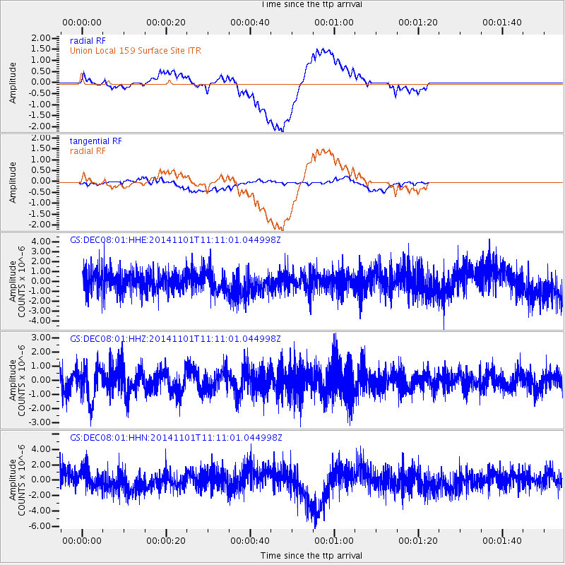
DEC08 Union Local 159 Surface Site - Earthquake Result Viewer
*The percent match for this event was below the threshold and hence no stack was calculated.
| Earthquake location: |
Easter Island Region |
| Earthquake latitude/longitude: |
-31.8/-111.2 |
| Earthquake time(UTC): |
2014/11/01 (305) 10:59:55 GMT |
| Earthquake Depth: |
10 km |
| Earthquake Magnitude: |
6.0 MWP |
| Earthquake Catalog/Contributor: |
NEIC PDE/NEIC COMCAT |
|
| Network: |
GS US Geological Survey Networks |
| Station: |
DEC08 Union Local 159 Surface Site |
| Lat/Lon: |
39.86 N/88.92 W |
| Elevation: |
210 m |
|
| Distance: |
74.3 deg |
| Az: |
17.631 deg |
| Baz: |
199.571 deg |
| Ray Param: |
$rayparam |
*The percent match for this event was below the threshold and hence was not used in the summary stack. |
|
| Radial Match: |
66.84087 % |
| Radial Bump: |
400 |
| Transverse Match: |
23.856476 % |
| Transverse Bump: |
400 |
| SOD ConfigId: |
3390531 |
| Insert Time: |
2019-04-14 19:41:27.342 +0000 |
| GWidth: |
2.5 |
| Max Bumps: |
400 |
| Tol: |
0.001 |
|
Signal To Noise
| Channel | StoN | STA | LTA |
| GS:DEC08:01:HHZ:20141101T11:11:01.044998Z | 1.6017635 | 1.2128254E-6 | 7.571813E-7 |
| GS:DEC08:01:HHN:20141101T11:11:01.044998Z | 0.6590018 | 1.5904444E-6 | 2.4134142E-6 |
| GS:DEC08:01:HHE:20141101T11:11:01.044998Z | 1.0787705 | 1.1445594E-6 | 1.060985E-6 |
| Arrivals |
| Ps | |
| PpPs | |
| PsPs/PpSs | |


