You are here: Home > Network List > NX - Nanometrics Research Network Stations List
> Station STN31 Seismic station 26 > Earthquake Result Viewer
STN31 Seismic station 26 - Earthquake Result Viewer
| Earthquake location: |
Easter Island Region |
| Earthquake latitude/longitude: |
-31.8/-111.2 |
| Earthquake time(UTC): |
2014/11/01 (305) 10:59:55 GMT |
| Earthquake Depth: |
10 km |
| Earthquake Magnitude: |
6.0 MWP |
| Earthquake Catalog/Contributor: |
NEIC PDE/NEIC COMCAT |
|
| Network: |
NX Nanometrics Research Network |
| Station: |
STN31 Seismic station 26 |
| Lat/Lon: |
35.76 N/97.44 W |
| Elevation: |
329 m |
|
| Distance: |
68.5 deg |
| Az: |
11.984 deg |
| Baz: |
192.552 deg |
| Ray Param: |
0.05629528 |
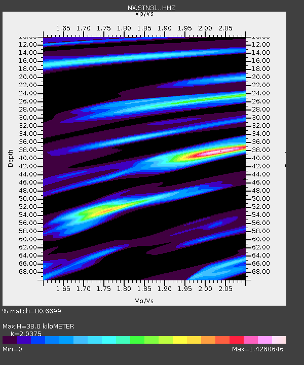
| Estimated Moho Depth: |
38.0 km |
| Estimated Crust Vp/Vs: |
2.04 |
| Assumed Crust Vp: |
6.426 km/s |
| Estimated Crust Vs: |
3.154 km/s |
| Estimated Crust Poisson's Ratio: |
0.34 |
|
| Radial Match: |
80.6699 % |
| Radial Bump: |
327 |
| Transverse Match: |
57.855354 % |
| Transverse Bump: |
279 |
| SOD ConfigId: |
3390531 |
| Insert Time: |
2019-04-14 19:42:52.956 +0000 |
| GWidth: |
2.5 |
| Max Bumps: |
400 |
| Tol: |
0.001 |
|

Signal To Noise
| Channel | StoN | STA | LTA |
| NX:STN31: :HHZ:20141101T11:10:26.169998Z | 7.5337415 | 1.3581341E-6 | 1.8027353E-7 |
| NX:STN31: :HH1:20141101T11:10:26.169998Z | 1.7810364 | 5.816926E-7 | 3.266034E-7 |
| NX:STN31: :HH2:20141101T11:10:26.169998Z | 1.9506395 | 5.0674646E-7 | 2.5978477E-7 |
| Arrivals |
| Ps | 6.3 SECOND |
| PpPs | 17 SECOND |
| PsPs/PpSs | 24 SECOND |


