You are here: Home > Network List > TA - USArray Transportable Network (new EarthScope stations) Stations List
> Station P43A Skaggs, Pawnee, IL, USA > Earthquake Result Viewer
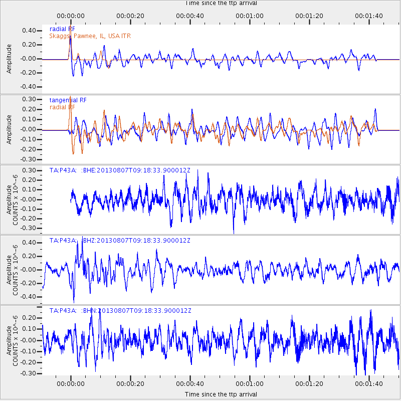
P43A Skaggs, Pawnee, IL, USA - Earthquake Result Viewer
*The percent match for this event was below the threshold and hence no stack was calculated.
| Earthquake location: |
Greece |
| Earthquake latitude/longitude: |
38.7/22.7 |
| Earthquake time(UTC): |
2013/08/07 (219) 09:06:52 GMT |
| Earthquake Depth: |
0.1 km |
| Earthquake Magnitude: |
5.5 MW, 5.3 MWR, 5.5 MWC |
| Earthquake Catalog/Contributor: |
NEIC PDE/NEIC COMCAT |
|
| Network: |
TA USArray Transportable Network (new EarthScope stations) |
| Station: |
P43A Skaggs, Pawnee, IL, USA |
| Lat/Lon: |
39.64 N/89.52 W |
| Elevation: |
176 m |
|
| Distance: |
80.4 deg |
| Az: |
313.529 deg |
| Baz: |
47.293 deg |
| Ray Param: |
$rayparam |
*The percent match for this event was below the threshold and hence was not used in the summary stack. |
|
| Radial Match: |
64.44037 % |
| Radial Bump: |
400 |
| Transverse Match: |
46.686184 % |
| Transverse Bump: |
375 |
| SOD ConfigId: |
626651 |
| Insert Time: |
2014-04-17 20:49:36.445 +0000 |
| GWidth: |
2.5 |
| Max Bumps: |
400 |
| Tol: |
0.001 |
|
Signal To Noise
| Channel | StoN | STA | LTA |
| TA:P43A: :BHZ:20130807T09:18:33.900012Z | 2.6050987 | 2.1663958E-7 | 8.315984E-8 |
| TA:P43A: :BHN:20130807T09:18:33.900012Z | 1.0958722 | 9.5313624E-8 | 8.6975135E-8 |
| TA:P43A: :BHE:20130807T09:18:33.900012Z | 1.8147006 | 1.1615963E-7 | 6.401036E-8 |
| Arrivals |
| Ps | |
| PpPs | |
| PsPs/PpSs | |


