You are here: Home > Network List > TA - USArray Transportable Network (new EarthScope stations) Stations List
> Station U59A Littleton, NC, USA > Earthquake Result Viewer
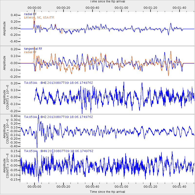
U59A Littleton, NC, USA - Earthquake Result Viewer
*The percent match for this event was below the threshold and hence no stack was calculated.
| Earthquake location: |
Greece |
| Earthquake latitude/longitude: |
38.7/22.7 |
| Earthquake time(UTC): |
2013/08/07 (219) 09:06:52 GMT |
| Earthquake Depth: |
0.1 km |
| Earthquake Magnitude: |
5.5 MW, 5.3 MWR, 5.5 MWC |
| Earthquake Catalog/Contributor: |
NEIC PDE/NEIC COMCAT |
|
| Network: |
TA USArray Transportable Network (new EarthScope stations) |
| Station: |
U59A Littleton, NC, USA |
| Lat/Lon: |
36.35 N/77.79 W |
| Elevation: |
99 m |
|
| Distance: |
75.4 deg |
| Az: |
304.88 deg |
| Baz: |
52.681 deg |
| Ray Param: |
$rayparam |
*The percent match for this event was below the threshold and hence was not used in the summary stack. |
|
| Radial Match: |
48.261665 % |
| Radial Bump: |
400 |
| Transverse Match: |
53.853725 % |
| Transverse Bump: |
400 |
| SOD ConfigId: |
626651 |
| Insert Time: |
2014-04-17 20:54:37.081 +0000 |
| GWidth: |
2.5 |
| Max Bumps: |
400 |
| Tol: |
0.001 |
|
Signal To Noise
| Channel | StoN | STA | LTA |
| TA:U59A: :BHZ:20130807T09:18:06.174976Z | 3.6363451 | 2.0606397E-7 | 5.666788E-8 |
| TA:U59A: :BHN:20130807T09:18:06.174976Z | 2.0972786 | 7.8802046E-8 | 3.7573475E-8 |
| TA:U59A: :BHE:20130807T09:18:06.174976Z | 1.5735158 | 8.836314E-8 | 5.61565E-8 |
| Arrivals |
| Ps | |
| PpPs | |
| PsPs/PpSs | |


