You are here: Home > Network List > TA - USArray Transportable Network (new EarthScope stations) Stations List
> Station W60A Pink Hill, NC, USA > Earthquake Result Viewer
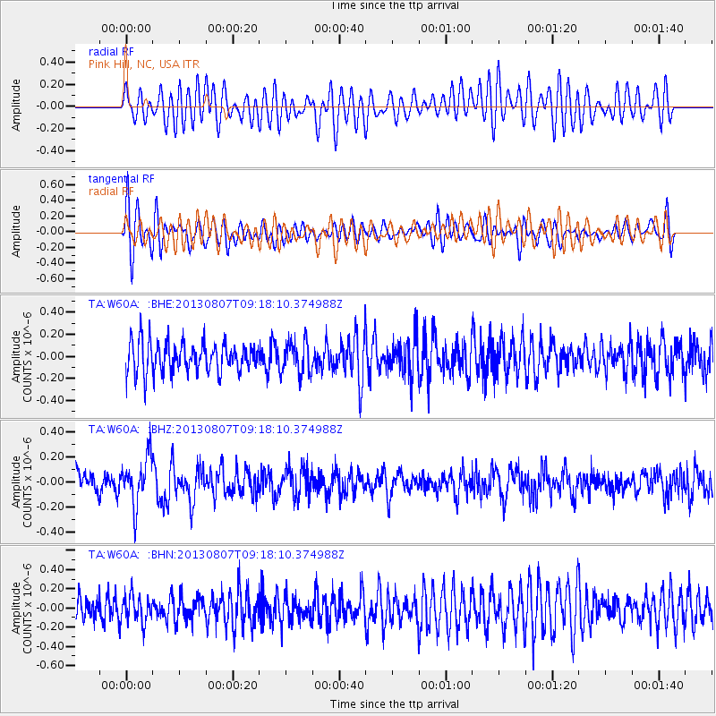
W60A Pink Hill, NC, USA - Earthquake Result Viewer
*The percent match for this event was below the threshold and hence no stack was calculated.
| Earthquake location: |
Greece |
| Earthquake latitude/longitude: |
38.7/22.7 |
| Earthquake time(UTC): |
2013/08/07 (219) 09:06:52 GMT |
| Earthquake Depth: |
0.1 km |
| Earthquake Magnitude: |
5.5 MW, 5.3 MWR, 5.5 MWC |
| Earthquake Catalog/Contributor: |
NEIC PDE/NEIC COMCAT |
|
| Network: |
TA USArray Transportable Network (new EarthScope stations) |
| Station: |
W60A Pink Hill, NC, USA |
| Lat/Lon: |
35.05 N/77.71 W |
| Elevation: |
30 m |
|
| Distance: |
76.1 deg |
| Az: |
303.777 deg |
| Baz: |
52.455 deg |
| Ray Param: |
$rayparam |
*The percent match for this event was below the threshold and hence was not used in the summary stack. |
|
| Radial Match: |
58.945045 % |
| Radial Bump: |
400 |
| Transverse Match: |
58.185017 % |
| Transverse Bump: |
400 |
| SOD ConfigId: |
626651 |
| Insert Time: |
2014-04-17 20:56:19.523 +0000 |
| GWidth: |
2.5 |
| Max Bumps: |
400 |
| Tol: |
0.001 |
|
Signal To Noise
| Channel | StoN | STA | LTA |
| TA:W60A: :BHZ:20130807T09:18:10.374988Z | 2.7503438 | 1.917952E-7 | 6.9734995E-8 |
| TA:W60A: :BHN:20130807T09:18:10.374988Z | 0.9200291 | 1.3651041E-7 | 1.4837619E-7 |
| TA:W60A: :BHE:20130807T09:18:10.374988Z | 1.079153 | 1.4918405E-7 | 1.382418E-7 |
| Arrivals |
| Ps | |
| PpPs | |
| PsPs/PpSs | |


