You are here: Home > Network List > YT07 - POLENET Stations List
> Station WAIS WAIS > Earthquake Result Viewer
WAIS WAIS - Earthquake Result Viewer
| Earthquake location: |
Easter Island Region |
| Earthquake latitude/longitude: |
-31.8/-111.2 |
| Earthquake time(UTC): |
2014/11/01 (305) 10:59:55 GMT |
| Earthquake Depth: |
10 km |
| Earthquake Magnitude: |
6.0 MWP |
| Earthquake Catalog/Contributor: |
NEIC PDE/NEIC COMCAT |
|
| Network: |
YT POLENET |
| Station: |
WAIS WAIS |
| Lat/Lon: |
79.42 S/111.78 W |
| Elevation: |
1800 m |
|
| Distance: |
47.7 deg |
| Az: |
180.15 deg |
| Baz: |
0.689 deg |
| Ray Param: |
0.069823526 |
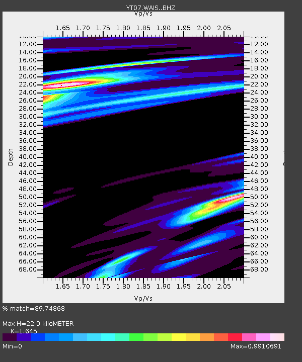
| Estimated Moho Depth: |
22.0 km |
| Estimated Crust Vp/Vs: |
1.64 |
| Assumed Crust Vp: |
5.833 km/s |
| Estimated Crust Vs: |
3.546 km/s |
| Estimated Crust Poisson's Ratio: |
0.21 |
|
| Radial Match: |
89.74868 % |
| Radial Bump: |
318 |
| Transverse Match: |
64.79757 % |
| Transverse Bump: |
400 |
| SOD ConfigId: |
3390531 |
| Insert Time: |
2019-04-14 19:47:50.943 +0000 |
| GWidth: |
2.5 |
| Max Bumps: |
400 |
| Tol: |
0.001 |
|

Signal To Noise
| Channel | StoN | STA | LTA |
| YT:WAIS: :BHZ:20141101T11:07:58.800002Z | 17.61453 | 3.282666E-6 | 1.8636125E-7 |
| YT:WAIS: :BHN:20141101T11:07:58.800002Z | 4.561608 | 8.188744E-7 | 1.7951443E-7 |
| YT:WAIS: :BHE:20141101T11:07:58.800002Z | 1.954136 | 2.8926002E-7 | 1.4802451E-7 |
| Arrivals |
| Ps | 2.6 SECOND |
| PpPs | 9.5 SECOND |
| PsPs/PpSs | 12 SECOND |


