You are here: Home > Network List > ZJ12 - Transantarctic Mountains Northern Network Stations List
> Station APRL East Antarctica > Earthquake Result Viewer
APRL East Antarctica - Earthquake Result Viewer
| Earthquake location: |
Easter Island Region |
| Earthquake latitude/longitude: |
-31.8/-111.2 |
| Earthquake time(UTC): |
2014/11/01 (305) 10:59:55 GMT |
| Earthquake Depth: |
10 km |
| Earthquake Magnitude: |
6.0 MWP |
| Earthquake Catalog/Contributor: |
NEIC PDE/NEIC COMCAT |
|
| Network: |
ZJ Transantarctic Mountains Northern Network |
| Station: |
APRL East Antarctica |
| Lat/Lon: |
73.19 S/158.70 E |
| Elevation: |
2258 m |
|
| Distance: |
59.9 deg |
| Az: |
199.648 deg |
| Baz: |
100.274 deg |
| Ray Param: |
0.06188646 |
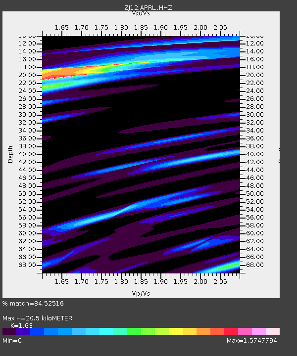
| Estimated Moho Depth: |
20.5 km |
| Estimated Crust Vp/Vs: |
1.63 |
| Assumed Crust Vp: |
6.306 km/s |
| Estimated Crust Vs: |
3.868 km/s |
| Estimated Crust Poisson's Ratio: |
0.20 |
|
| Radial Match: |
84.52516 % |
| Radial Bump: |
400 |
| Transverse Match: |
73.86438 % |
| Transverse Bump: |
400 |
| SOD ConfigId: |
3390531 |
| Insert Time: |
2019-04-14 19:48:00.328 +0000 |
| GWidth: |
2.5 |
| Max Bumps: |
400 |
| Tol: |
0.001 |
|

Signal To Noise
| Channel | StoN | STA | LTA |
| ZJ:APRL: :HHZ:20141101T11:09:28.029006Z | 23.267792 | 3.7619025E-6 | 1.6167853E-7 |
| ZJ:APRL: :HHN:20141101T11:09:28.029006Z | 1.5186279 | 3.244616E-7 | 2.1365445E-7 |
| ZJ:APRL: :HHE:20141101T11:09:28.029006Z | 3.5337825 | 7.292417E-7 | 2.0636293E-7 |
| Arrivals |
| Ps | 2.2 SECOND |
| PpPs | 8.1 SECOND |
| PsPs/PpSs | 10 SECOND |


