You are here: Home > Network List > NY - Yukon Northwest Seismic Network(YNSN) Stations List
> Station MAYO Mayo, Yukon, CANADA > Earthquake Result Viewer
MAYO Mayo, Yukon, CANADA - Earthquake Result Viewer
| Earthquake location: |
Fiji Islands Region |
| Earthquake latitude/longitude: |
-19.7/-177.7 |
| Earthquake time(UTC): |
2014/11/01 (305) 18:57:22 GMT |
| Earthquake Depth: |
434 km |
| Earthquake Magnitude: |
7.1 MWW, 6.9 MI, 7.1 MWC, 7.2 MWB |
| Earthquake Catalog/Contributor: |
NEIC PDE/NEIC COMCAT |
|
| Network: |
NY Yukon Northwest Seismic Network(YNSN) |
| Station: |
MAYO Mayo, Yukon, CANADA |
| Lat/Lon: |
63.60 N/135.89 W |
| Elevation: |
0.0 m |
|
| Distance: |
89.2 deg |
| Az: |
17.353 deg |
| Baz: |
218.942 deg |
| Ray Param: |
0.041653253 |
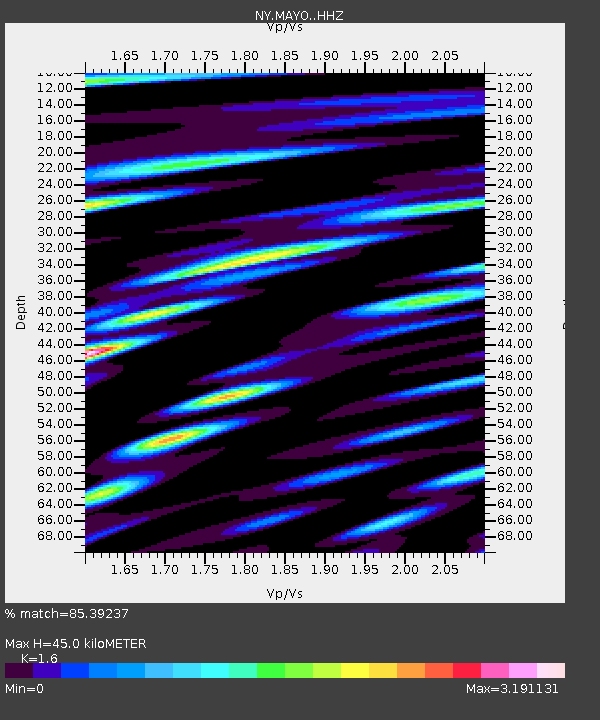
| Estimated Moho Depth: |
45.0 km |
| Estimated Crust Vp/Vs: |
1.60 |
| Assumed Crust Vp: |
6.419 km/s |
| Estimated Crust Vs: |
4.012 km/s |
| Estimated Crust Poisson's Ratio: |
0.18 |
|
| Radial Match: |
85.39237 % |
| Radial Bump: |
400 |
| Transverse Match: |
73.22445 % |
| Transverse Bump: |
400 |
| SOD ConfigId: |
3390531 |
| Insert Time: |
2019-04-14 19:51:39.077 +0000 |
| GWidth: |
2.5 |
| Max Bumps: |
400 |
| Tol: |
0.001 |
|

Signal To Noise
| Channel | StoN | STA | LTA |
| NY:MAYO: :HHZ:20141101T19:08:59.669973Z | 20.86615 | 4.2225806E-6 | 2.023651E-7 |
| NY:MAYO: :HHN:20141101T19:08:59.669973Z | 2.0533981 | 1.6083668E-6 | 7.832708E-7 |
| NY:MAYO: :HHE:20141101T19:08:59.669973Z | 2.544709 | 1.1185487E-6 | 4.3955856E-7 |
| Arrivals |
| Ps | 4.3 SECOND |
| PpPs | 18 SECOND |
| PsPs/PpSs | 22 SECOND |


