You are here: Home > Network List > II - Global Seismograph Network (GSN - IRIS/IDA) Stations List
> Station WRAB Tennant Creek, NT, Australia > Earthquake Result Viewer
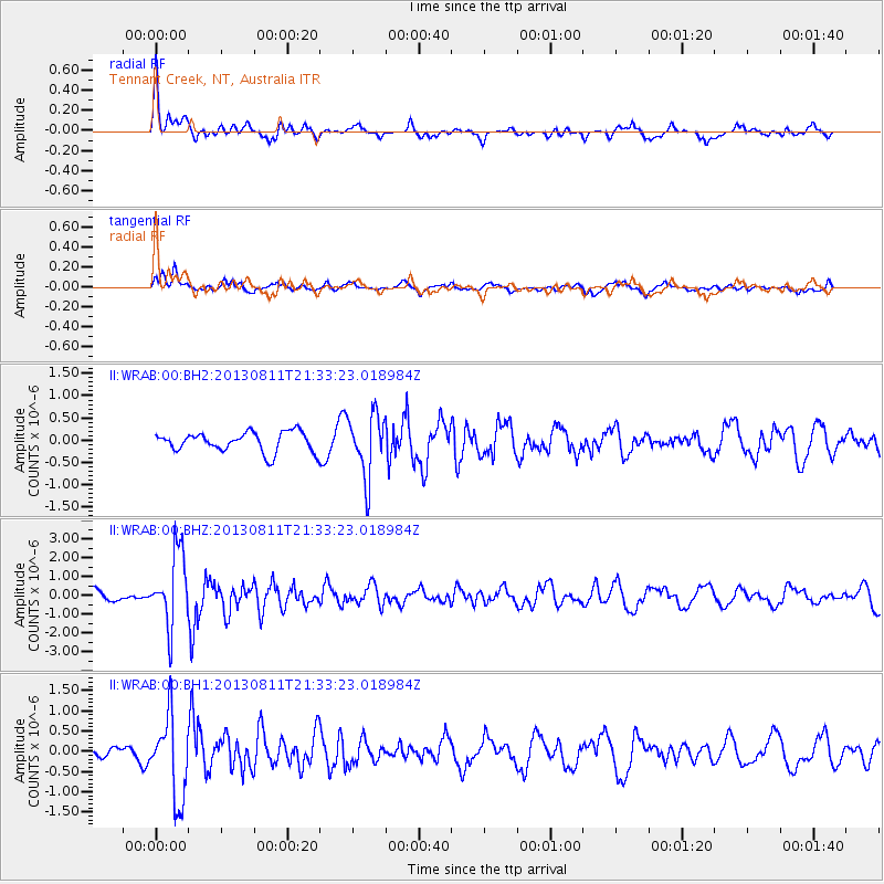
WRAB Tennant Creek, NT, Australia - Earthquake Result Viewer
*The percent match for this event was below the threshold and hence no stack was calculated.
| Earthquake location: |
Xizang |
| Earthquake latitude/longitude: |
30.0/98.0 |
| Earthquake time(UTC): |
2013/08/11 (223) 21:23:41 GMT |
| Earthquake Depth: |
6.0 km |
| Earthquake Magnitude: |
5.7 MWW, 5.6 MWB, 5.7 MWW, 5.8 MWC |
| Earthquake Catalog/Contributor: |
NEIC PDE/NEIC COMCAT |
|
| Network: |
II Global Seismograph Network (GSN - IRIS/IDA) |
| Station: |
WRAB Tennant Creek, NT, Australia |
| Lat/Lon: |
19.93 S/134.36 E |
| Elevation: |
366 m |
|
| Distance: |
60.8 deg |
| Az: |
140.24 deg |
| Baz: |
323.883 deg |
| Ray Param: |
$rayparam |
*The percent match for this event was below the threshold and hence was not used in the summary stack. |
|
| Radial Match: |
77.044785 % |
| Radial Bump: |
400 |
| Transverse Match: |
61.716442 % |
| Transverse Bump: |
400 |
| SOD ConfigId: |
626651 |
| Insert Time: |
2014-04-17 21:17:08.454 +0000 |
| GWidth: |
2.5 |
| Max Bumps: |
400 |
| Tol: |
0.001 |
|
Signal To Noise
| Channel | StoN | STA | LTA |
| II:WRAB:00:BHZ:20130811T21:33:23.018984Z | 7.6406355 | 1.9519841E-6 | 2.5547405E-7 |
| II:WRAB:00:BH1:20130811T21:33:23.018984Z | 5.149022 | 1.0149647E-6 | 1.9711796E-7 |
| II:WRAB:00:BH2:20130811T21:33:23.018984Z | 3.2047925 | 6.9928933E-7 | 2.1820112E-7 |
| Arrivals |
| Ps | |
| PpPs | |
| PsPs/PpSs | |


