You are here: Home > Network List > XD14 - Illuminating the architecture of the greater Mount St. Helens magmatic systems f Stations List
> Station MA05 "Mount St Helens, WA" > Earthquake Result Viewer
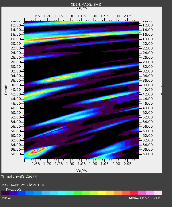
MA05 "Mount St Helens, WA" - Earthquake Result Viewer
| Earthquake location: |
Fiji Islands Region |
| Earthquake latitude/longitude: |
-19.7/-177.7 |
| Earthquake time(UTC): |
2014/11/01 (305) 18:57:22 GMT |
| Earthquake Depth: |
434 km |
| Earthquake Magnitude: |
7.1 MWW, 6.9 MI, 7.1 MWC, 7.2 MWB |
| Earthquake Catalog/Contributor: |
NEIC PDE/NEIC COMCAT |
|
| Network: |
XD Illuminating the architecture of the greater Mount St. Helens magmatic systems f |
| Station: |
MA05 "Mount St Helens, WA" |
| Lat/Lon: |
46.75 N/122.23 W |
| Elevation: |
488 m |
|
| Distance: |
82.9 deg |
| Az: |
34.823 deg |
| Baz: |
231.493 deg |
| Ray Param: |
0.045372162 |
| Estimated Moho Depth: |
66.25 km |
| Estimated Crust Vp/Vs: |
1.65 |
| Assumed Crust Vp: |
6.566 km/s |
| Estimated Crust Vs: |
3.967 km/s |
| Estimated Crust Poisson's Ratio: |
0.21 |
|
| Radial Match: |
83.25674 % |
| Radial Bump: |
400 |
| Transverse Match: |
73.82934 % |
| Transverse Bump: |
400 |
| SOD ConfigId: |
3390531 |
| Insert Time: |
2019-04-14 19:53:21.180 +0000 |
| GWidth: |
2.5 |
| Max Bumps: |
400 |
| Tol: |
0.001 |
|

Signal To Noise
| Channel | StoN | STA | LTA |
| XD:MA05: :BHZ:20141101T19:08:29.61498Z | 6.938129 | 2.5032216E-6 | 3.6079203E-7 |
| XD:MA05: :BHN:20141101T19:08:29.61498Z | 3.8564053 | 5.988034E-7 | 1.5527502E-7 |
| XD:MA05: :BHE:20141101T19:08:29.61498Z | 3.3664296 | 6.964103E-7 | 2.0686913E-7 |
| Arrivals |
| Ps | 6.8 SECOND |
| PpPs | 26 SECOND |
| PsPs/PpSs | 33 SECOND |


