You are here: Home > Network List > IU - Global Seismograph Network (GSN - IRIS/USGS) Stations List
> Station FURI Mt. Furi, Ethiopia > Earthquake Result Viewer
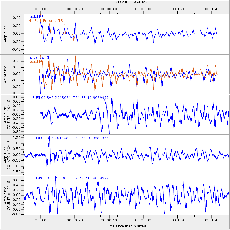
FURI Mt. Furi, Ethiopia - Earthquake Result Viewer
*The percent match for this event was below the threshold and hence no stack was calculated.
| Earthquake location: |
Xizang |
| Earthquake latitude/longitude: |
30.0/98.0 |
| Earthquake time(UTC): |
2013/08/11 (223) 21:23:41 GMT |
| Earthquake Depth: |
6.0 km |
| Earthquake Magnitude: |
5.7 MWW, 5.6 MWB, 5.7 MWW, 5.8 MWC |
| Earthquake Catalog/Contributor: |
NEIC PDE/NEIC COMCAT |
|
| Network: |
IU Global Seismograph Network (GSN - IRIS/USGS) |
| Station: |
FURI Mt. Furi, Ethiopia |
| Lat/Lon: |
8.90 N/38.68 E |
| Elevation: |
2570 m |
|
| Distance: |
59.1 deg |
| Az: |
262.072 deg |
| Baz: |
60.354 deg |
| Ray Param: |
$rayparam |
*The percent match for this event was below the threshold and hence was not used in the summary stack. |
|
| Radial Match: |
64.17236 % |
| Radial Bump: |
400 |
| Transverse Match: |
65.462105 % |
| Transverse Bump: |
400 |
| SOD ConfigId: |
626651 |
| Insert Time: |
2014-04-17 21:17:25.159 +0000 |
| GWidth: |
2.5 |
| Max Bumps: |
400 |
| Tol: |
0.001 |
|
Signal To Noise
| Channel | StoN | STA | LTA |
| IU:FURI:00:BHZ:20130811T21:33:10.968997Z | 3.3867993 | 4.609814E-7 | 1.3611123E-7 |
| IU:FURI:00:BH1:20130811T21:33:10.968997Z | 2.1550736 | 2.4284284E-7 | 1.1268424E-7 |
| IU:FURI:00:BH2:20130811T21:33:10.968997Z | 1.4249691 | 1.9837177E-7 | 1.3921127E-7 |
| Arrivals |
| Ps | |
| PpPs | |
| PsPs/PpSs | |


