You are here: Home > Network List > TA - USArray Transportable Network (new EarthScope stations) Stations List
> Station TCOL CIGO, UAF Yankovich Road, Fairbanks, AK, USA > Earthquake Result Viewer
TCOL CIGO, UAF Yankovich Road, Fairbanks, AK, USA - Earthquake Result Viewer
| Earthquake location: |
Xizang |
| Earthquake latitude/longitude: |
30.0/98.0 |
| Earthquake time(UTC): |
2013/08/11 (223) 21:23:41 GMT |
| Earthquake Depth: |
6.0 km |
| Earthquake Magnitude: |
5.7 MWW, 5.6 MWB, 5.7 MWW, 5.8 MWC |
| Earthquake Catalog/Contributor: |
NEIC PDE/NEIC COMCAT |
|
| Network: |
TA USArray Transportable Network (new EarthScope stations) |
| Station: |
TCOL CIGO, UAF Yankovich Road, Fairbanks, AK, USA |
| Lat/Lon: |
64.87 N/147.86 W |
| Elevation: |
178 m |
|
| Distance: |
72.6 deg |
| Az: |
24.088 deg |
| Baz: |
304.018 deg |
| Ray Param: |
0.053553846 |
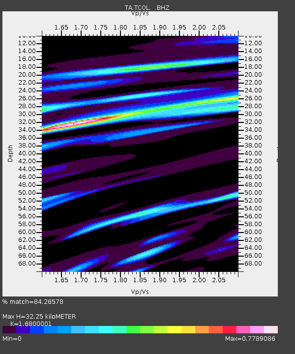
| Estimated Moho Depth: |
32.25 km |
| Estimated Crust Vp/Vs: |
1.68 |
| Assumed Crust Vp: |
6.566 km/s |
| Estimated Crust Vs: |
3.908 km/s |
| Estimated Crust Poisson's Ratio: |
0.23 |
|
| Radial Match: |
84.26578 % |
| Radial Bump: |
400 |
| Transverse Match: |
68.29634 % |
| Transverse Bump: |
400 |
| SOD ConfigId: |
626651 |
| Insert Time: |
2014-04-17 21:22:51.418 +0000 |
| GWidth: |
2.5 |
| Max Bumps: |
400 |
| Tol: |
0.001 |
|

Signal To Noise
| Channel | StoN | STA | LTA |
| TA:TCOL: :BHZ:20130811T21:34:38.150027Z | 19.698036 | 1.3113329E-6 | 6.657176E-8 |
| TA:TCOL: :BHN:20130811T21:34:38.150027Z | 3.6121857 | 4.0971946E-7 | 1.1342702E-7 |
| TA:TCOL: :BHE:20130811T21:34:38.150027Z | 4.208808 | 5.701359E-7 | 1.3546256E-7 |
| Arrivals |
| Ps | 3.5 SECOND |
| PpPs | 13 SECOND |
| PsPs/PpSs | 16 SECOND |


