You are here: Home > Network List > XD14 - Illuminating the architecture of the greater Mount St. Helens magmatic systems f Stations List
> Station MK12 "Mount St Helens, WA" > Earthquake Result Viewer
MK12 "Mount St Helens, WA" - Earthquake Result Viewer
| Earthquake location: |
Fiji Islands Region |
| Earthquake latitude/longitude: |
-19.7/-177.7 |
| Earthquake time(UTC): |
2014/11/01 (305) 18:57:22 GMT |
| Earthquake Depth: |
434 km |
| Earthquake Magnitude: |
7.1 MWW, 6.9 MI, 7.1 MWC, 7.2 MWB |
| Earthquake Catalog/Contributor: |
NEIC PDE/NEIC COMCAT |
|
| Network: |
XD Illuminating the architecture of the greater Mount St. Helens magmatic systems f |
| Station: |
MK12 "Mount St Helens, WA" |
| Lat/Lon: |
46.11 N/121.36 W |
| Elevation: |
1226 m |
|
| Distance: |
83.0 deg |
| Az: |
35.702 deg |
| Baz: |
232.224 deg |
| Ray Param: |
0.045321252 |
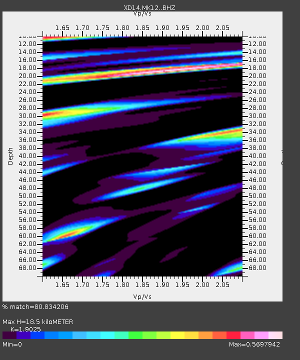
| Estimated Moho Depth: |
18.5 km |
| Estimated Crust Vp/Vs: |
1.90 |
| Assumed Crust Vp: |
6.597 km/s |
| Estimated Crust Vs: |
3.468 km/s |
| Estimated Crust Poisson's Ratio: |
0.31 |
|
| Radial Match: |
80.834206 % |
| Radial Bump: |
379 |
| Transverse Match: |
69.1803 % |
| Transverse Bump: |
400 |
| SOD ConfigId: |
3390531 |
| Insert Time: |
2019-04-14 19:53:52.727 +0000 |
| GWidth: |
2.5 |
| Max Bumps: |
400 |
| Tol: |
0.001 |
|

Signal To Noise
| Channel | StoN | STA | LTA |
| XD:MK12: :BHZ:20141101T19:08:29.98998Z | 4.4600596 | 1.922E-6 | 4.309359E-7 |
| XD:MK12: :BHN:20141101T19:08:29.98998Z | 1.4959651 | 4.6845622E-7 | 3.1314647E-7 |
| XD:MK12: :BHE:20141101T19:08:29.98998Z | 1.7301248 | 5.499055E-7 | 3.178415E-7 |
| Arrivals |
| Ps | 2.6 SECOND |
| PpPs | 7.9 SECOND |
| PsPs/PpSs | 11 SECOND |


