You are here: Home > Network List > UW - Pacific Northwest Regional Seismic Network Stations List
> Station LEBA Lebam, WA, USA > Earthquake Result Viewer
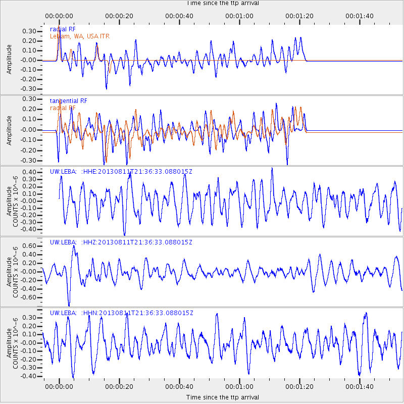
LEBA Lebam, WA, USA - Earthquake Result Viewer
*The percent match for this event was below the threshold and hence no stack was calculated.
| Earthquake location: |
Xizang |
| Earthquake latitude/longitude: |
30.0/98.0 |
| Earthquake time(UTC): |
2013/08/11 (223) 21:23:41 GMT |
| Earthquake Depth: |
6.0 km |
| Earthquake Magnitude: |
5.7 MWW, 5.6 MWB, 5.7 MWW, 5.8 MWC |
| Earthquake Catalog/Contributor: |
NEIC PDE/NEIC COMCAT |
|
| Network: |
UW Pacific Northwest Regional Seismic Network |
| Station: |
LEBA Lebam, WA, USA |
| Lat/Lon: |
46.55 N/123.56 W |
| Elevation: |
73 m |
|
| Distance: |
95.0 deg |
| Az: |
27.341 deg |
| Baz: |
324.762 deg |
| Ray Param: |
$rayparam |
*The percent match for this event was below the threshold and hence was not used in the summary stack. |
|
| Radial Match: |
51.333263 % |
| Radial Bump: |
400 |
| Transverse Match: |
67.3709 % |
| Transverse Bump: |
400 |
| SOD ConfigId: |
626651 |
| Insert Time: |
2014-04-17 21:23:32.368 +0000 |
| GWidth: |
2.5 |
| Max Bumps: |
400 |
| Tol: |
0.001 |
|
Signal To Noise
| Channel | StoN | STA | LTA |
| UW:LEBA: :HHZ:20130811T21:36:33.088015Z | 2.1844656 | 3.2278652E-7 | 1.4776452E-7 |
| UW:LEBA: :HHN:20130811T21:36:33.088015Z | 1.1478195 | 2.0563122E-7 | 1.7914944E-7 |
| UW:LEBA: :HHE:20130811T21:36:33.088015Z | 0.700673 | 1.3426518E-7 | 1.9162317E-7 |
| Arrivals |
| Ps | |
| PpPs | |
| PsPs/PpSs | |


