You are here: Home > Network List > YT07 - POLENET Stations List
> Station N140 N140 > Earthquake Result Viewer
N140 N140 - Earthquake Result Viewer
| Earthquake location: |
Fiji Islands Region |
| Earthquake latitude/longitude: |
-19.7/-177.7 |
| Earthquake time(UTC): |
2014/11/01 (305) 18:57:22 GMT |
| Earthquake Depth: |
434 km |
| Earthquake Magnitude: |
7.1 MWW, 6.9 MI, 7.1 MWC, 7.2 MWB |
| Earthquake Catalog/Contributor: |
NEIC PDE/NEIC COMCAT |
|
| Network: |
YT POLENET |
| Station: |
N140 N140 |
| Lat/Lon: |
82.01 S/96.76 E |
| Elevation: |
3570 m |
|
| Distance: |
70.0 deg |
| Az: |
188.536 deg |
| Baz: |
88.41 deg |
| Ray Param: |
0.053889014 |
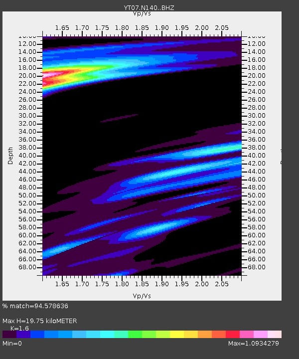
| Estimated Moho Depth: |
19.75 km |
| Estimated Crust Vp/Vs: |
1.60 |
| Assumed Crust Vp: |
6.261 km/s |
| Estimated Crust Vs: |
3.913 km/s |
| Estimated Crust Poisson's Ratio: |
0.18 |
|
| Radial Match: |
94.578636 % |
| Radial Bump: |
400 |
| Transverse Match: |
88.26527 % |
| Transverse Bump: |
400 |
| SOD ConfigId: |
3390531 |
| Insert Time: |
2019-04-14 19:54:33.472 +0000 |
| GWidth: |
2.5 |
| Max Bumps: |
400 |
| Tol: |
0.001 |
|

Signal To Noise
| Channel | StoN | STA | LTA |
| YT:N140: :BHZ:20141101T19:07:17.148977Z | 241.42969 | 3.782248E-5 | 1.5666043E-7 |
| YT:N140: :BHN:20141101T19:07:17.148977Z | 13.884291 | 2.1920712E-6 | 1.578814E-7 |
| YT:N140: :BHE:20141101T19:07:17.148977Z | 51.543053 | 6.93633E-6 | 1.3457353E-7 |
| Arrivals |
| Ps | 2.0 SECOND |
| PpPs | 7.9 SECOND |
| PsPs/PpSs | 9.9 SECOND |


