You are here: Home > Network List > CB - China National Seismic Network Stations List
> Station GTA Gaotai,Gansu Province > Earthquake Result Viewer
GTA Gaotai,Gansu Province - Earthquake Result Viewer
| Earthquake location: |
Banda Sea |
| Earthquake latitude/longitude: |
-7.1/129.8 |
| Earthquake time(UTC): |
2013/08/12 (224) 00:53:43 GMT |
| Earthquake Depth: |
95 km |
| Earthquake Magnitude: |
6.0 MWW, 6.0 MWW, 6.1 MWB, 6.1 MWC |
| Earthquake Catalog/Contributor: |
NEIC PDE/NEIC COMCAT |
|
| Network: |
CB China National Seismic Network |
| Station: |
GTA Gaotai,Gansu Province |
| Lat/Lon: |
39.40 N/99.82 E |
| Elevation: |
1345 m |
|
| Distance: |
54.0 deg |
| Az: |
331.392 deg |
| Baz: |
142.176 deg |
| Ray Param: |
0.065450855 |
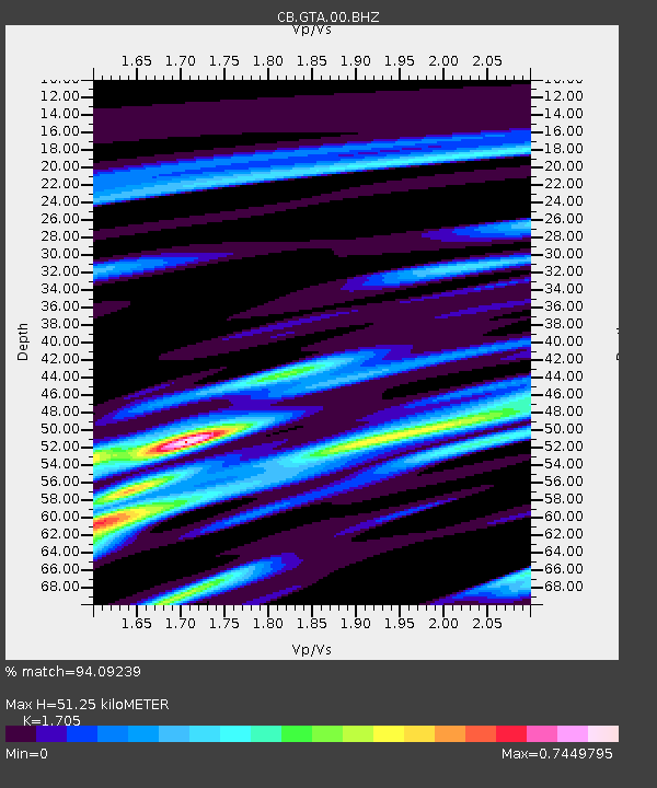
| Estimated Moho Depth: |
51.25 km |
| Estimated Crust Vp/Vs: |
1.71 |
| Assumed Crust Vp: |
6.491 km/s |
| Estimated Crust Vs: |
3.807 km/s |
| Estimated Crust Poisson's Ratio: |
0.24 |
|
| Radial Match: |
94.09239 % |
| Radial Bump: |
253 |
| Transverse Match: |
83.81691 % |
| Transverse Bump: |
330 |
| SOD ConfigId: |
626651 |
| Insert Time: |
2014-04-17 21:29:58.083 +0000 |
| GWidth: |
2.5 |
| Max Bumps: |
400 |
| Tol: |
0.001 |
|

Signal To Noise
| Channel | StoN | STA | LTA |
| CB:GTA:00:BHZ:20130812T01:02:27.610005Z | 49.484062 | 1.4396511E-6 | 2.9093227E-8 |
| CB:GTA:00:BHN:20130812T01:02:27.610005Z | 37.293854 | 5.492108E-7 | 1.4726577E-8 |
| CB:GTA:00:BHE:20130812T01:02:27.610005Z | 33.40135 | 4.4591522E-7 | 1.3350217E-8 |
| Arrivals |
| Ps | 5.9 SECOND |
| PpPs | 20 SECOND |
| PsPs/PpSs | 26 SECOND |


