You are here: Home > Network List > CB - China National Seismic Network Stations List
> Station HEH Heihe,Heilongjiang Province > Earthquake Result Viewer
HEH Heihe,Heilongjiang Province - Earthquake Result Viewer

| Earthquake location: |
Banda Sea |
| Earthquake latitude/longitude: |
-7.1/129.8 |
| Earthquake time(UTC): |
2013/08/12 (224) 00:53:43 GMT |
| Earthquake Depth: |
95 km |
| Earthquake Magnitude: |
6.0 MWW, 6.0 MWW, 6.1 MWB, 6.1 MWC |
| Earthquake Catalog/Contributor: |
NEIC PDE/NEIC COMCAT |
|
| Network: |
CB China National Seismic Network |
| Station: |
HEH Heihe,Heilongjiang Province |
| Lat/Lon: |
50.25 N/127.41 E |
| Elevation: |
165 m |
|
| Distance: |
57.2 deg |
| Az: |
358.168 deg |
| Baz: |
177.167 deg |
| Ray Param: |
0.06337813 |
| Estimated Moho Depth: |
31.75 km |
| Estimated Crust Vp/Vs: |
1.82 |
| Assumed Crust Vp: |
6.419 km/s |
| Estimated Crust Vs: |
3.532 km/s |
| Estimated Crust Poisson's Ratio: |
0.28 |
|
| Radial Match: |
95.528915 % |
| Radial Bump: |
298 |
| Transverse Match: |
87.894905 % |
| Transverse Bump: |
400 |
| SOD ConfigId: |
626651 |
| Insert Time: |
2014-04-17 21:30:03.147 +0000 |
| GWidth: |
2.5 |
| Max Bumps: |
400 |
| Tol: |
0.001 |
|
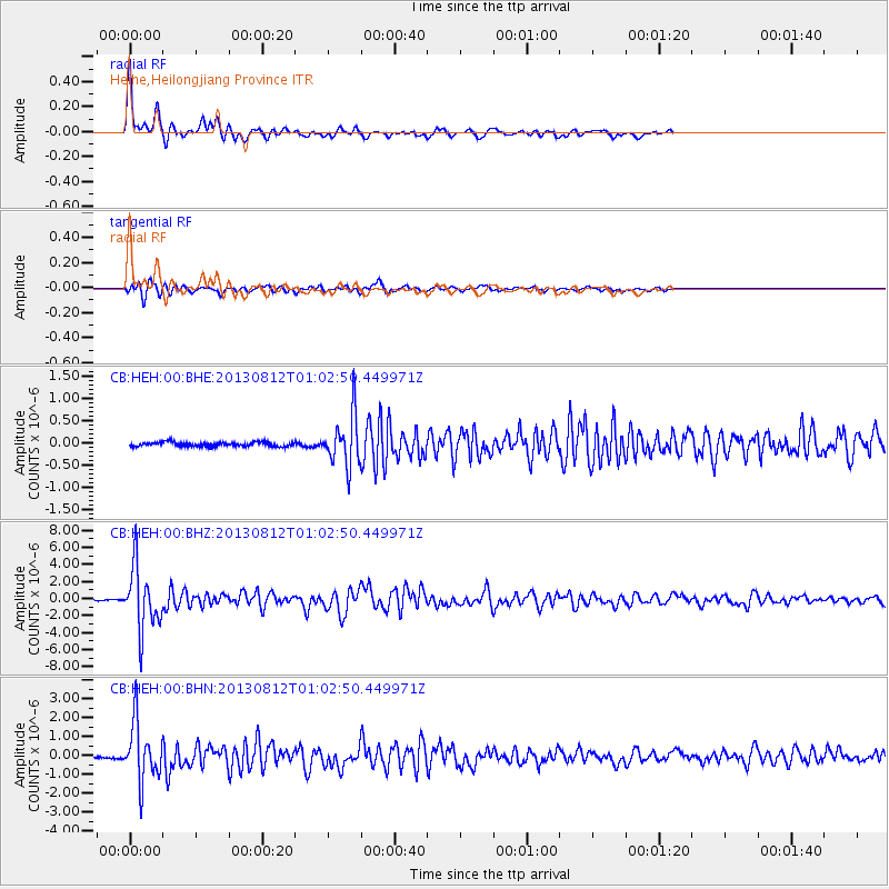
Signal To Noise
| Channel | StoN | STA | LTA |
| CB:HEH:00:BHZ:20130812T01:02:50.449971Z | 65.430664 | 3.6711501E-6 | 5.6107485E-8 |
| CB:HEH:00:BHN:20130812T01:02:50.449971Z | 31.358524 | 1.5368705E-6 | 4.9009653E-8 |
| CB:HEH:00:BHE:20130812T01:02:50.449971Z | 12.535262 | 5.747187E-7 | 4.584816E-8 |
| Arrivals |
| Ps | 4.2 SECOND |
| PpPs | 13 SECOND |
| PsPs/PpSs | 18 SECOND |


