You are here: Home > Network List > GO - National Seismic Network of Georgia Stations List
> Station AKH Akhalkalaki, Georgia > Earthquake Result Viewer
AKH Akhalkalaki, Georgia - Earthquake Result Viewer
| Earthquake location: |
Banda Sea |
| Earthquake latitude/longitude: |
-7.1/129.8 |
| Earthquake time(UTC): |
2013/08/12 (224) 00:53:43 GMT |
| Earthquake Depth: |
95 km |
| Earthquake Magnitude: |
6.0 MWW, 6.0 MWW, 6.1 MWB, 6.1 MWC |
| Earthquake Catalog/Contributor: |
NEIC PDE/NEIC COMCAT |
|
| Network: |
GO National Seismic Network of Georgia |
| Station: |
AKH Akhalkalaki, Georgia |
| Lat/Lon: |
41.41 N/43.49 E |
| Elevation: |
1708 m |
|
| Distance: |
91.9 deg |
| Az: |
311.318 deg |
| Baz: |
97.753 deg |
| Ray Param: |
0.041499253 |
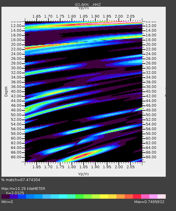
| Estimated Moho Depth: |
10.25 km |
| Estimated Crust Vp/Vs: |
2.03 |
| Assumed Crust Vp: |
6.419 km/s |
| Estimated Crust Vs: |
3.158 km/s |
| Estimated Crust Poisson's Ratio: |
0.34 |
|
| Radial Match: |
87.474304 % |
| Radial Bump: |
400 |
| Transverse Match: |
83.65777 % |
| Transverse Bump: |
400 |
| SOD ConfigId: |
626651 |
| Insert Time: |
2014-04-17 21:31:20.521 +0000 |
| GWidth: |
2.5 |
| Max Bumps: |
400 |
| Tol: |
0.001 |
|

Signal To Noise
| Channel | StoN | STA | LTA |
| GO:AKH: :HHZ:20130812T01:06:10.45998Z | 38.35154 | 1.8049701E-6 | 4.706382E-8 |
| GO:AKH: :HHN:20130812T01:06:10.45998Z | 3.2677522 | 1.0280065E-7 | 3.1459134E-8 |
| GO:AKH: :HHE:20130812T01:06:10.45998Z | 13.297098 | 3.3281108E-7 | 2.5028852E-8 |
| Arrivals |
| Ps | 1.7 SECOND |
| PpPs | 4.8 SECOND |
| PsPs/PpSs | 6.4 SECOND |


