You are here: Home > Network List > IU - Global Seismograph Network (GSN - IRIS/USGS) Stations List
> Station XMAS Kiritimati Island, Republic of Kiribati > Earthquake Result Viewer
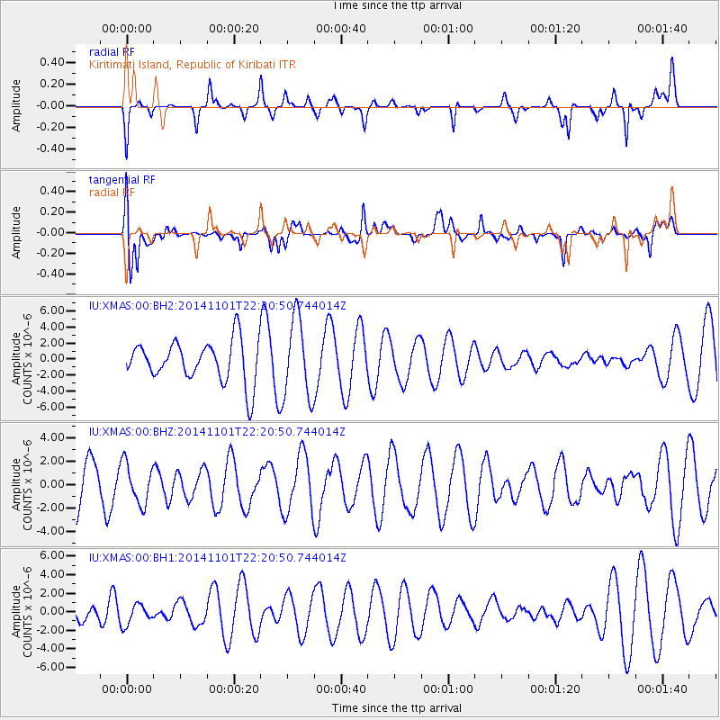
XMAS Kiritimati Island, Republic of Kiribati - Earthquake Result Viewer
*The percent match for this event was below the threshold and hence no stack was calculated.
| Earthquake location: |
Solomon Islands |
| Earthquake latitude/longitude: |
-9.8/159.8 |
| Earthquake time(UTC): |
2014/11/01 (305) 22:13:14 GMT |
| Earthquake Depth: |
26 km |
| Earthquake Magnitude: |
5.6 mb, 5.6 mb, 5.2 MS |
| Earthquake Catalog/Contributor: |
ISC/ISC |
|
| Network: |
IU Global Seismograph Network (GSN - IRIS/USGS) |
| Station: |
XMAS Kiritimati Island, Republic of Kiribati |
| Lat/Lon: |
2.04 N/157.45 W |
| Elevation: |
20 m |
|
| Distance: |
44.2 deg |
| Az: |
76.813 deg |
| Baz: |
253.779 deg |
| Ray Param: |
$rayparam |
*The percent match for this event was below the threshold and hence was not used in the summary stack. |
|
| Radial Match: |
39.45013 % |
| Radial Bump: |
249 |
| Transverse Match: |
50.64035 % |
| Transverse Bump: |
400 |
| SOD ConfigId: |
3390531 |
| Insert Time: |
2019-04-14 19:58:00.625 +0000 |
| GWidth: |
2.5 |
| Max Bumps: |
400 |
| Tol: |
0.001 |
|
Signal To Noise
| Channel | StoN | STA | LTA |
| IU:XMAS:00:BHZ:20141101T22:20:50.744014Z | 0.86987346 | 1.7382072E-6 | 1.9982301E-6 |
| IU:XMAS:00:BH1:20141101T22:20:50.744014Z | 0.93057096 | 1.1021856E-6 | 1.1844187E-6 |
| IU:XMAS:00:BH2:20141101T22:20:50.744014Z | 1.9307895 | 4.9610458E-6 | 2.569439E-6 |
| Arrivals |
| Ps | |
| PpPs | |
| PsPs/PpSs | |


