You are here: Home > Network List > KG - Korean Seismic Network- KIGAM Stations List
> Station TJN Taejon, Republic of Korea > Earthquake Result Viewer
TJN Taejon, Republic of Korea - Earthquake Result Viewer
| Earthquake location: |
Banda Sea |
| Earthquake latitude/longitude: |
-7.1/129.8 |
| Earthquake time(UTC): |
2013/08/12 (224) 00:53:43 GMT |
| Earthquake Depth: |
95 km |
| Earthquake Magnitude: |
6.0 MWW, 6.0 MWW, 6.1 MWB, 6.1 MWC |
| Earthquake Catalog/Contributor: |
NEIC PDE/NEIC COMCAT |
|
| Network: |
KG Korean Seismic Network- KIGAM |
| Station: |
TJN Taejon, Republic of Korea |
| Lat/Lon: |
36.38 N/127.36 E |
| Elevation: |
60 m |
|
| Distance: |
43.3 deg |
| Az: |
357.125 deg |
| Baz: |
176.464 deg |
| Ray Param: |
0.07228248 |
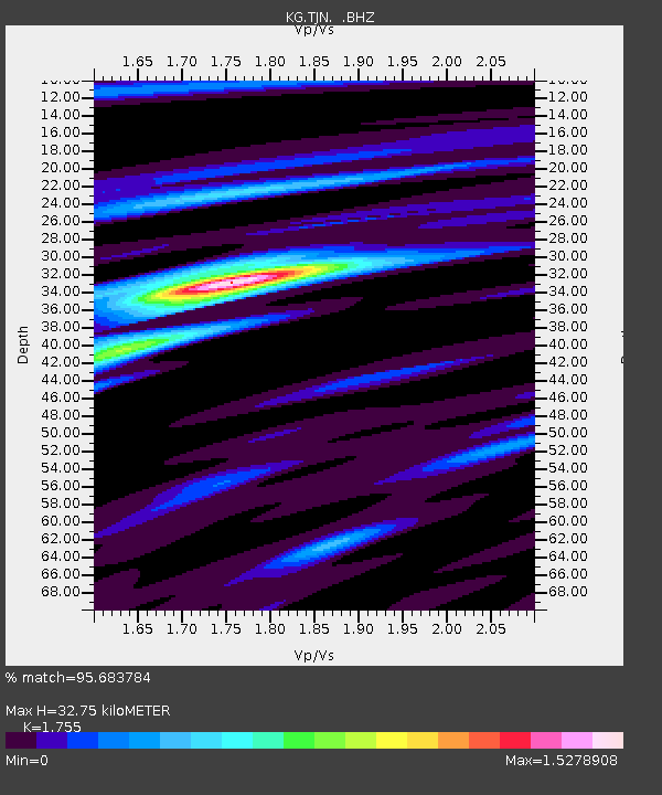
| Estimated Moho Depth: |
32.75 km |
| Estimated Crust Vp/Vs: |
1.75 |
| Assumed Crust Vp: |
6.459 km/s |
| Estimated Crust Vs: |
3.681 km/s |
| Estimated Crust Poisson's Ratio: |
0.26 |
|
| Radial Match: |
95.683784 % |
| Radial Bump: |
287 |
| Transverse Match: |
84.30687 % |
| Transverse Bump: |
400 |
| SOD ConfigId: |
626651 |
| Insert Time: |
2014-04-17 21:36:06.352 +0000 |
| GWidth: |
2.5 |
| Max Bumps: |
400 |
| Tol: |
0.001 |
|

Signal To Noise
| Channel | StoN | STA | LTA |
| KG:TJN: :BHZ:20130812T01:01:06.284993Z | 22.082695 | 2.8564943E-6 | 1.2935443E-7 |
| KG:TJN: :BHN:20130812T01:01:06.284993Z | 20.06066 | 1.5774569E-6 | 7.863435E-8 |
| KG:TJN: :BHE:20130812T01:01:06.284993Z | 2.200668 | 2.0429412E-7 | 9.283278E-8 |
| Arrivals |
| Ps | 4.1 SECOND |
| PpPs | 13 SECOND |
| PsPs/PpSs | 17 SECOND |


